
Does your fleet size and frequency of trips exceed the capabilities of off-the-shelf mapping platforms? This means it's time to develop a proprietary multi-stop route planner. Below, we've analyzed the architectural features and system components underlying such solutions.
Why Basic Route Planning Tools Fail for Growing Fleets
Standard mapping services and navigation systems have proven effective in solving local problems, but when it comes to managing a commercial fleet, their functionality is insufficient. As the logistics workload increases, they impose the following limitations on logistics companies:
- Limited number of points. The interfaces of such systems are limited in the number of intermediate points in a single route (usually no more than 10-20 ones), making it impossible to build multi-stage logistics chains for couriers.
- There is no fleet-level optimization. The algorithms are unable to distribute a pool of orders among multiple vehicles, taking into account their time slots and driver work schedules. They also do not take into account the load capacity of a specific vehicle.
- No dynamic adjustments. Such solutions lack the ability to replan routes in real time based on conditions that arise while the driver is already en route (traffic jams, canceled orders, etc.).
- No personnel management features. Such systems typically lack specialized tools for monitoring driver status, enforcing labor code compliance (such as FMCSA), and confirming delivery.
- They lack necessary connectors for third-party services. The lack of reliable APIs for synchronizing with legacy solutions your company may be using forces operators to transfer data manually.
- They lack automatic route generation. The route generation process in out-of-the-box solutions often relies on manual data entry, which leads to a high probability of human error and is extremely time-consuming.
- They lack scalability. The architecture of such solutions often cannot handle the rapid growth of transaction load as the number of orders processed increases.
Core Features of a Scalable Multi-Stop Route Planner
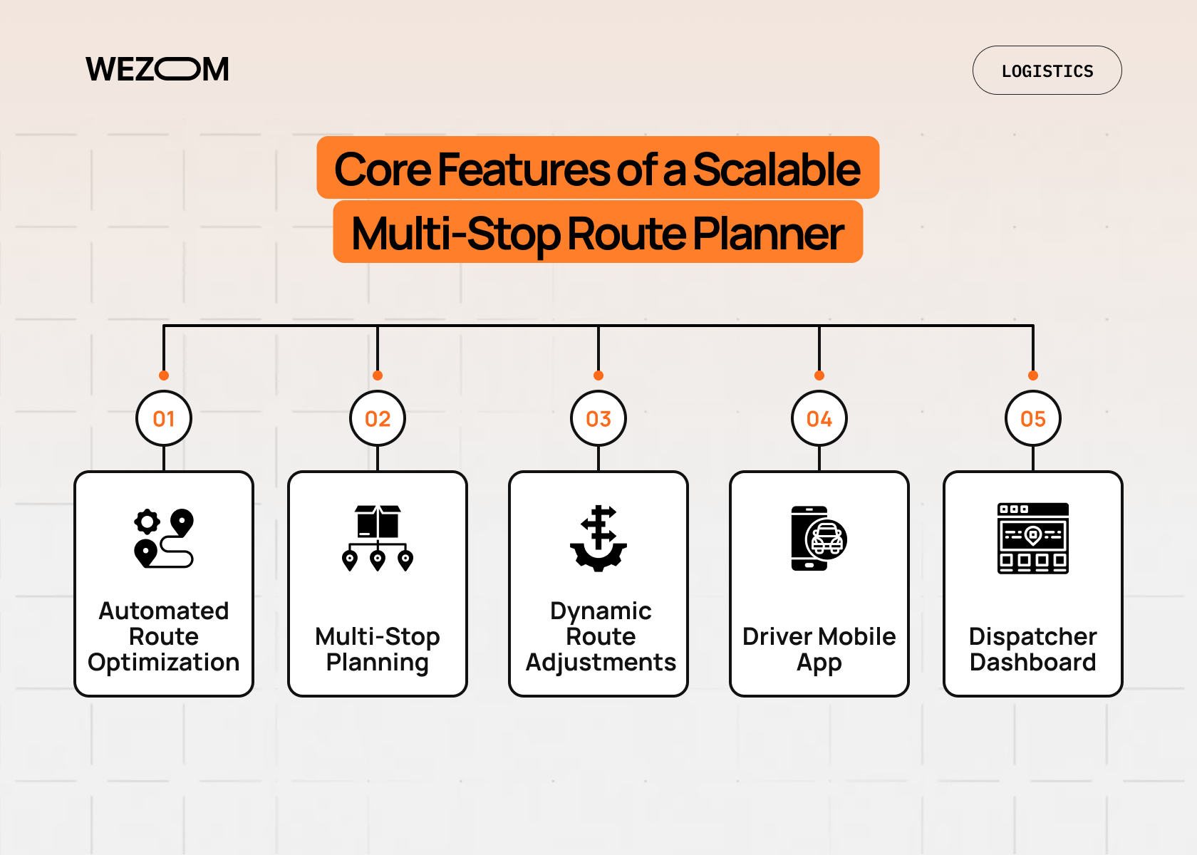
To ensure the efficient operation of a constantly scaling fleet of vehicles, the software must include the following modules:
- Automated route optimization, with algorithm-based task distribution and minimization of total mileage, fuel consumption, travel time, etc.;
- Multi-stop delivery planning and sequencing, with calculation of the optimal order of trips taking into account priorities, cargo dimensions, customer time windows, and driver schedules;
- Dynamic route adjustments, with consideration of current traffic jams or changes in input data;
- A mobile route planning app for delivery drivers with a turn-by-turn navigation interface, task status recording, digital signature/photo report collection, and availability in areas with poor internet connection;
- A dispatcher dashboard with the ability to monitor the fleet in real time, analyze each driver's KPIs, plan driver schedules for FMCSA compliance, and monitor deviations from the plan.
Architecture Behind a Scalable Multi-Stop Route Planner
Designing a multi stop flight route planner requires a four-component architecture.
Frontend app
This layer consists of two main parts. The first is the dispatcher's web panel, which is developed using component frameworks like React and requires the integration of high-performance mapping libraries to visualize vehicle movements in real time. The second part is the mobile client for drivers. Typically, this is a cross-platform application for receiving tasks. It operates offline with local data caching and sending telemetry.
Backend and API layer
The system core is implemented using scalable languages and frameworks such as Node.js, which can guarantee maximum throughput. This component must include an API gateway for managing requests, load balancing, and user authentication, as well as message brokers that ensure asynchronous data exchange between microservices when streaming telemetry from mobile devices. The core also includes relational DBMSs for storing geospatial data, users, and orders, as well as NoSQL DBs for caching and geo-calculations.
Mapping and geolocation services
The mapping and geolocation part is responsible for spatial data processing, including geocoding (converting text addresses into geographic coordinates and vice versa) and routing (with the construction of distance matrices and the calculation of the shortest paths taking into account the road graph).
Optimization engine
This engine handles resource-intensive mathematical optimization problems of a combinatorial nature, with strict time windows and load capacity constraints. It is typically implemented as a high-performance microservice and interacts with an asynchronous queue to calculate routes in batches in minimal time.
How to Build a Multi-Stop Route Planner Step by Step
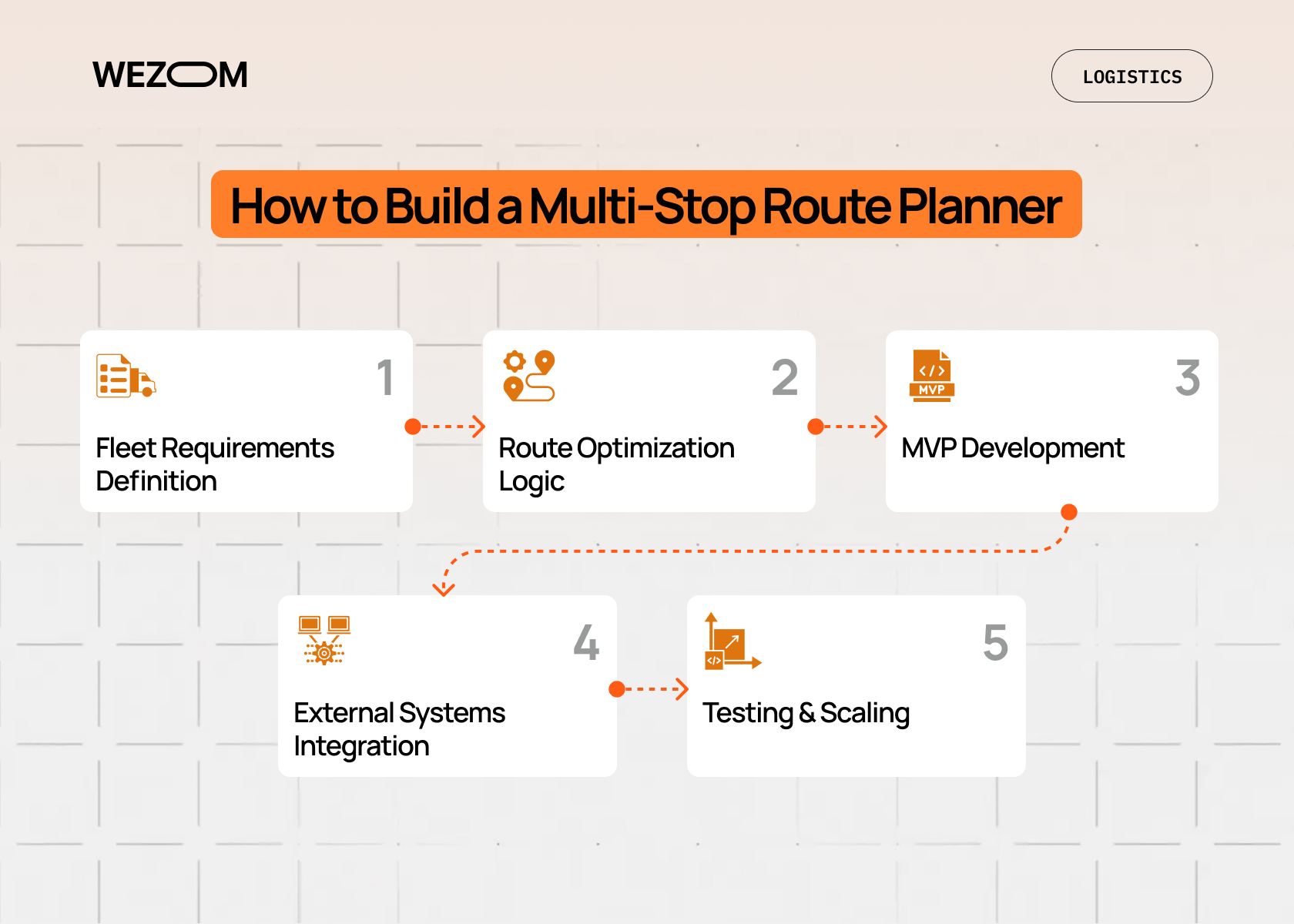
Developing a scalable mapquest multi stop route planner requires a well-thought-out technical approach consisting of five sequential steps.
Fleet requirements definition
It all begins with collecting and formalizing business requirements. The team must thoroughly study the specifics of the fleet, including vehicle types, their payload capacity, usable cargo volume, dimensions, fuel consumption restrictions, etc. It's also important to consider the cargo specifics, legally permissible driver work schedules, and the geographic coverage area. Based on these parameters, the team develops the technical specifications for the entire project.
Route optimization logic development
At this stage of multi stop route planner app development, the core of the system is formed. Here, it’s essential to implement mathematical models of the classic vehicle routing problem, taking into account time windows and capacity constraints. System architects must also determine which heuristic/metaheuristic algorithms should be used to calculate optimal trajectories when processing thousands of orders. Finally, the development team must design distance matrices and implement integration with cartographic graphs.
MVP development
During the MVP phase, the team creates manual/semi-automated order import, automated route generation, and a dispatcher and driver account builder. At this phase, developers must also lay the foundation for the dispatcher's web interface and a mobile app for drivers (where drivers can receive waybills, track order statuses, etc.).
Integration of external systems
The planner is typically not standalone; it must exchange data with other company systems. That’s why, at this stage, the team implements its integration with corporate systems such as ERP, WMS, CRM, payment gateway, GPS/GLONASS telematics tracker, and others.
Testing and scaling
This stage includes comprehensive load and functional testing, during which the team evaluates the performance of optimization algorithms under peak loads. The backend's resilience to interrupted connections to drivers' mobile devices is also analyzed. Once the system successfully passes these tests, it is deployed to a cloud infrastructure with automatic scaling configured to quickly adapt to potential increases in transaction load.
Technologies Used in Multi-Stop Route Planner Development
The correctly chosen tech stack determines fault tolerance, scalability, overall performance, adaptability to rapid changes, and, of course, the cost of supporting the custom solution.
For example, for the backend, we recommend using the following technologies:
- Java, which is considered an excellent choice for high-load systems due to its stability, strong typing, and high scalability;
- Python, an excellent solution for implementing complex mathematical optimization algorithms, as well as working with geodata and machine learning libraries;
- Node.js, a technology that ensures high-speed processing of asynchronous requests in real time;
- .NET, an optimal solution for integration with corporate ecosystems.
As for the frontend, the following technologies have proven themselves excellent:
- React, a framework for creating interactive control panels with high-density rendering maps;
- Angular, an excellent solution for enterprise-grade software with a strict architecture;
- Vue, a lightweight tool for rapid user interface development.
For mobile software, the following technologies have to be considered first:
- Flutter, a modern cross-platform framework with a wealth of available integrations;
- React Native, a tool for cross-platform JavaScript/TypeScript development with access to geomodules;
- Swift/Kotlin, languages for native development that provide top-notch performance and integration with smartphone hardware.
If you're going to implement a cloud solution, these market leaders make sense to check:
- AWS, well-known for its advanced solutions for geographic data distribution and load balancing;
- Azure, ideal for integrating enterprise infrastructure with the Microsoft stack;
- Google Cloud Platform, a solution with native integration with Google Maps API mapping services and advanced Big Data analytics tools.
Finally, for database and caching implementation, you must check the following tools:
- PostgreSQL, a relational DBMS with the PostGIS extension for storing geodata and routes;
- Redis, an ultra-fast in-memory data storage, perfect for caching and real-time queue processing;
- MongoDB/Cassandra, NoSQL databases for unstructured logs and telemetry from trackers.
AI/ML in Route Optimization
The integration of AI algorithms makes multi stop delivery route planners even more efficient. In particular, with this approach to software implementation, dispatchers gain the ability to adaptively respond to changing environmental factors. This is all thanks to existing historical data and predictive analytics built into the software. Specifically, such planners enable:
- Demand prediction, including analysis of seasonality, holidays, weather conditions, historical patterns, etc., for accurate forecasting of order volumes in specific areas;
- Delivery time estimation, with precise calculation of arrival times taking into account numerous dynamic parameters;
- Traffic prediction, with real-time traffic congestion/jam analysis based on current road conditions and historical data;
- Fuel optimization, with route selection based on terrain and vehicle speed/load;
- Driver behavior analysis, including identification of sudden acceleration, braking, speeding, overtime, etc.;
- Automated decision-making for instant order redistribution in the event of machine breakdowns, order cancellations, and other force majeure events.
Custom Multi-Stop Route Planner vs Ready-Made Apps
The choice between an off-the-shelf solution and developing your own software depends on a number of aspects, which we propose to consider in the table below:
| Feature | Ready-made apps | Custom route planner |
|---|---|---|
| The number of stops | Up to 100-200 points | Can be scaled for any fleet size |
| Fleet management | Basic monitoring tools | In-depth customization capabilities |
| Integrations | Limited number of standard integrations | Any integration can be implemented |
| Optimization rules | Primitive algorithms | Fine-tuning according to unique rules and constraints of a specific business |
| Scalability | Depends on the vendor’s tariff | Unlimited |
| App for drivers | Standardized | Tailored to your company’s specifics |
| Analytics | Basic reporting | Extended BI analytics |
Industries That Benefit from Multi-Stop Route Planning Software
Let's look at the main industries where the implementation of specialized systems brings the fastest ROI.
Trucking
In long-haul trucking, every extra kilometer/hour of downtime results in significant financial losses. Routing systems come to the rescue here, helping dispatchers build supply chains of any complexity, taking into account the location of distribution centers, vehicle weight and size restrictions, road capacity, driver work and rest schedules, and other aspects. This automation reduces fuel consumption and wear and tear on expensive equipment.
Last-mile delivery
Delivery of goods to end consumers is the most unpredictable stage of the logistics chain, due to the high density of delivery points in residential areas, the lack of parking, traffic jams, and tight customer time windows. Multi-stop planners, on the other hand, automate the distribution of orders among drivers, minimizing the time spent on manual scheduling and allowing dispatchers to process many times more orders per shift.
Courier services
Express delivery services prioritize rapid response to new orders. Integrating schedulers with CRM systems enables immediate addition of urgent shipments to existing courier routes, recalculating the optimal route without disrupting previously scheduled delivery times and thereby ensuring a high level of customer service.
Retail distribution
Retail chains require regular deliveries from central warehouses. Route planner multi stop software in this context helps create delivery schedules based on product proximity and truck capacity. This ensures that perishable goods or special offers reach shelves on time.
Food delivery
In food delivery, speed and temperature control are crucial, so courier delays or violations of transportation regulations result in order returns. Routing tools based on predictive traffic analysis algorithms enable hot delivery and the consolidation of orders from the same restaurant within a service area.
Healthcare logistics
Transporting pharmaceuticals, equipment, and biomaterials requires strict compliance and has no room for logistical errors. Route planners are capable of taking temperature requirements and prioritizing urgent emergency calls into account. They also seamlessly integrate with laboratory information systems.
Field services
Coordination of mobile teams is always based on the personnel's qualifications and the availability of necessary spare parts in the vehicle. In this context, the system can optimize the routes of mobile technicians to reduce travel time between sites, enabling a rapid response to emergency calls and dispatching the nearest available technician with the necessary tools.
eCommerce fulfillment
The rapid growth of online retail requires automation of a number of processes, from the moment an order is placed on the website to its delivery to the end customer. Integrating the planner with WMS systems ensures seamless transfer of goods to the loading area and allows operators to instantly create routes for the online store's fleet.
Common Mistakes When Developing a Route Planning Platform
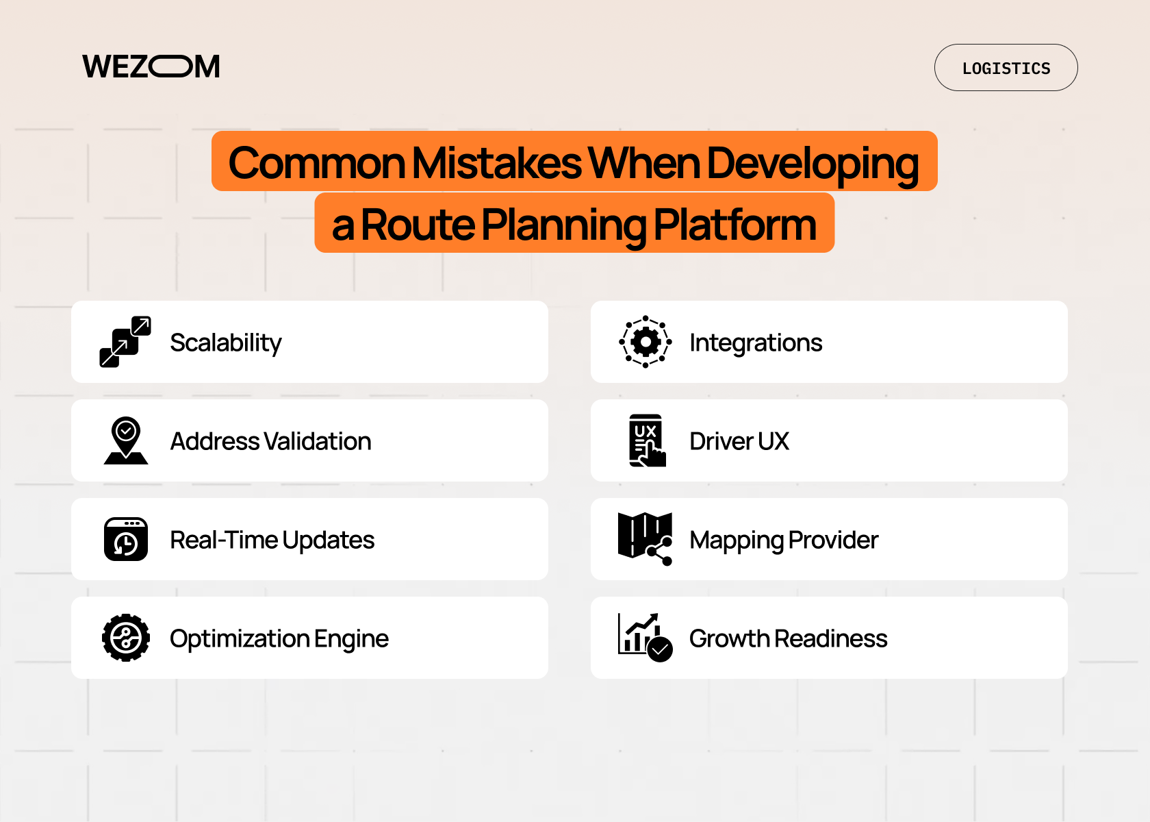
When developing a custom multi-stop delivery route planner, inexperienced teams often make a number of mistakes, including:
- Neglecting scalability. Database limits and backend task processing constraints lead to system slowdowns as the number of orders increases. The solution is to design an architecture based on microservices and a relational DBMS with horizontal scalability support.
- Weak address validation. Due to the lack of proper geocoding and autocomplete, drivers may arrive at incorrect addresses or receive inaccurate coordinates, resulting in missed delivery times. To prevent this, teams should integrate geocoders with predictive input, syntax validation, and automatic geocoordinate verification.
- Lack of real-time updates. Static routes can become outdated due to traffic jams or customer cancellations. To prevent this, developers need to implement message brokers and web sockets to enable streaming telemetry and dynamic route recalculation.
- Weak optimization engine. Using basic algorithms instead of VRP mathematical models doesn't allow for capacity and time windows to be taken into account. The solution is to develop or integrate a specialized computing core in high-performance languages to solve multi-factor routing problems.
- Lack of integrations. The planner's isolation from corporate systems forces operators to manually transfer data. To automate all workflows, you need to implement a universal API layer in the backend for automatic two-way data synchronization with third-party systems.
- Underestimation of driver UX. An overly sophisticated interface distracts couriers from the road. The solution is to build a cross-platform interface with large controls, an offline mode, and status recording in a single tap.
- Lack of transparent analytics. The lack of clear dashboards and reports don’t allow dispatchers to assess the actual efficiency of their fleet and identify excessive fuel consumption. As a solution, you can integrate BI dashboards for real-time monitoring of mileage, fuel consumption, percentage of scheduled deliveries, etc.
- Choosing the wrong mapping provider. Many vendors offer poor road graph quality, leading to impossible maneuvers on the road. To avoid this, you need to thoroughly test mapping services before integration and select those that take into account the specifics of regional traffic.
- Lack of readiness for growth. Designing software without scalability in mind leads to its freezing and the inability to add new features. As a solution, it makes sense to ensure multi-tenancy and RBAC into the architecture from the start to enable the integration of new geographic zones and fleets.
Conclusion
Developing a custom delivery route planning software allows businesses to maximize their existing fleets while eliminating dependence on third-party services. Custom planners can also adapt to a company's unique business processes, thereby establishing a reliable foundation for scaling logistics workflows in the future.

FAQ
What is a multi stop route planner used for?
Multi stop route planners automatically calculate the optimal sequence of deliveries across dozens or even hundreds of destinations. They help reduce total driving distance, lower fuel consumption, improve delivery efficiency, and ensure compliance with customer time windows.
How does a multi stop route planner optimize delivery routes?
Multi stop route planning software analyzes geospatial data, road networks, distance matrices, customer delivery windows, vehicle capacities, and driver schedules to generate the most efficient delivery routes.
How many stops can a multi-stop route planner handle?
Custom multi-stop route planning solutions have virtually no fixed architectural limit. They can optimize routes containing thousands of delivery points across hundreds of vehicles simultaneously, depending on the available infrastructure and computational resources.
Can a multi stop route planner work with real-time traffic data?
Yes. Multi stop route planners can integrate with mapping services and telematics systems to monitor live traffic conditions and dynamically recalculate routes when congestion, road closures, or other disruptions occur.
How does delivery route planning software reduce operational costs?
Delivery route planning software reduces costs by minimizing fleet mileage, lowering fuel consumption, reducing vehicle wear, improving driver productivity, and decreasing the need for manual planning, which also helps reduce human error.
