
Two sensor technologies dominate drone detection procurement: radar, which sees the aircraft as a physical object, and radio frequency monitoring, which listens for the link between drone and operator. They fail in opposite ways. Radar struggles with small airframes flying close to terrain; RF sensors go blind the moment a drone follows a pre-programmed route. Where each one breaks down decides whether a site gets usable airspace awareness or unactionable alerts.
Counter-Drone Radar and RF Detection in Modern C-UAS Systems
What counter-drone detection systems need to detect and track
Airspace security work splits into detection, tracking, and identification. A counter-drone detection system must register that something is airborne, hold a track with position and altitude, separate a drone from a bird, and deliver that picture early enough to act on.
Active radar detection vs passive RF monitoring
Radar transmits energy and measures what returns, registering any object with sufficient radar cross-section, however the drone is flown. RF sensors transmit nothing, monitoring the spectrum for control and video links, which keeps them covert but dependent on the drone emitting.
Why no single sensor can detect every drone threat
Each approach has a defined blind spot. Autonomous and fiber-optic drones produce no RF signature; carbon-fiber FPV airframes under a kilogram return little energy and fly inside ground clutter. No single sensor covers the full threat set.
How Counter-Drone Radar Detects and Tracks UAVs
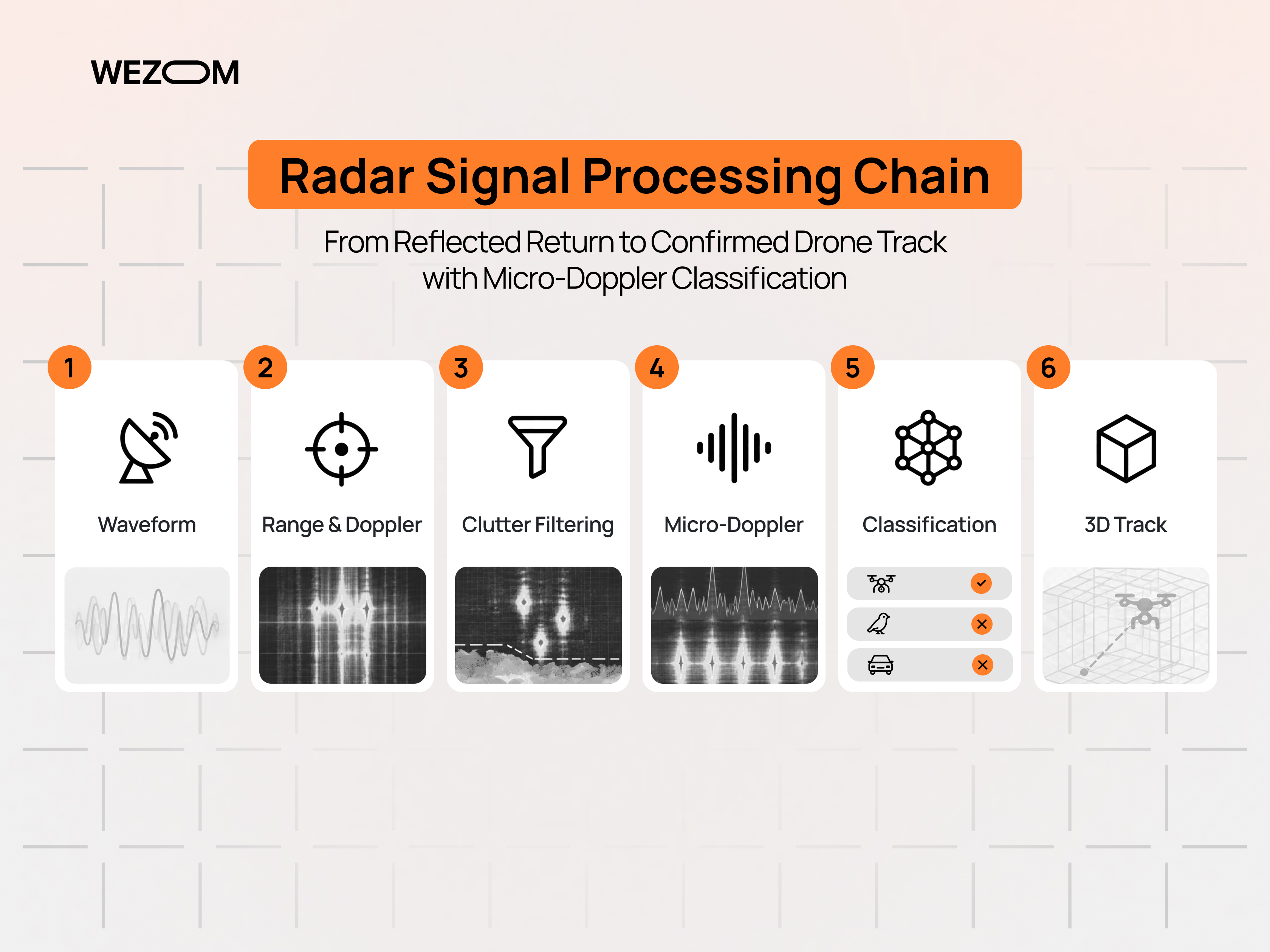
How radar identifies physical objects in low-altitude airspace
A drone detection radar emits pulses or a continuous waveform and processes reflections for range, bearing, and Doppler shift. Purpose-built counter-UAS sets work in X-band (8–12 GHz) or Ku-band (12–18 GHz), where the wavelength returns usable energy from centimetre-scale rotor assemblies.
Range, coverage, position, altitude, speed, and trajectory tracking
Track quality separates a counter-drone radar from a proximity alarm. A 3D set reports azimuth, elevation, range and radial velocity, letting the tracker build a flight path and project the aircraft forward, provided the update rate survives a sharp change of heading.
Detecting autonomous and RF-silent drones with radar
Detection depends on reflected energy rather than emissions, so radar sees a waypoint mission exactly as it sees manual flight. That is the argument for counter-UAV radar where the threat includes GPS-guided or fiber-optic aircraft.
Radar cross-section challenges with small drones and FPV UAVs
Detection range scales with the fourth root of radar cross-section, so a quadcopter presenting roughly 0.01 m² is detected far closer in than a fixed-wing UAV. Range figures mean something only when tied to a stated target size, altitude, and probability of detection.
Ground clutter, birds, buildings, weather, and false alarms
Low-altitude airspace is crowded with returns from terrain, vehicles, cranes,s and moving vegetation, and birds occupy a similar size and speed envelope to a quadcopter. Micro-Doppler processing separates blade rotation from wing beats. Higher bands resolve finer detail but attenuate more in rain.
How RF Drone Detection Works
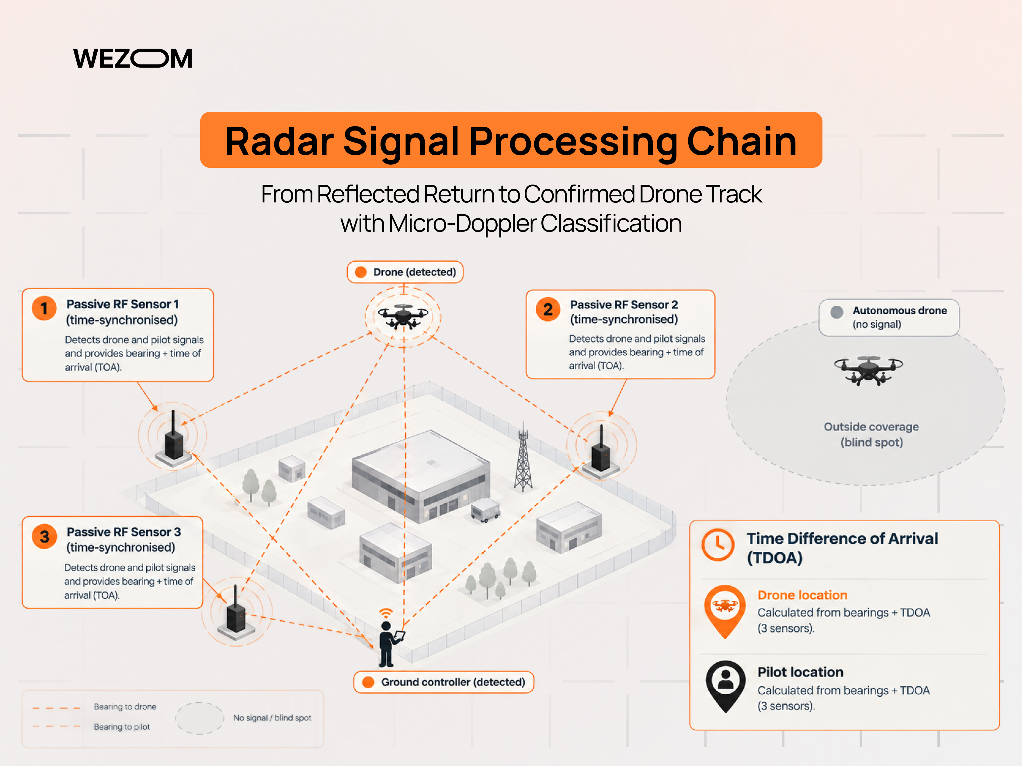
Detecting communication links between drones and controllers
RF sensors observe the uplink and downlink between aircraft and controller. Consumer platforms concentrate in the 2.4 GHz and 5.8 GHz ISM bands, while wideband receivers sweep 400 MHz to above 6 GHz for long-range and custom links. Detection often happens before takeoff.
RF spectrum monitoring, signal identification, and direction finding
Classification matches observed waveform characteristics against a protocol library of known models. Direction finding comes from line-of-bearing using directional arrays, or from time difference of arrival across networked receivers. An RF detection system for drones reports a bearing first, refining it once enough sensors hold the same emitter.
Drone and pilot localization capabilities
Monitoring both ends of the link is what radar cannot replicate. Three or more time-synchronised sensors produce coordinates for the aircraft and a separate position for the operator, though accuracy depends on sensor geometry, and encrypted links block telemetry extraction.
Advantages of passive RF detection for covert monitoring
Passive operation means no transmission licence, no emissions revealing the sensor position, and no interference with airport equipment. Installation costs are lower than radar, and the same receivers log identifiers that become forensic evidence.
Where RF detection struggles with autonomous and non-emitting drones
A drone flying a waypoint mission with its transmitter disabled is invisible, and fiber-optic control removes the RF signature entirely. Library-based classification also fails against DIY airframes running open-source flight stacks, while urban multipath can displace a reported position by hundreds of metres.
Counter-Drone Radar vs RF Detection: Key Differences

Detection range and coverage comparison
Published radar ranges against small quadcopters commonly fall in the low single-digit kilometres, while RF ranges against consumer drones sit in a comparable band but degrade sharply with terrain and noise. The practical difference is shape: radar coverage is a defined volume, RF coverage a propagation-dependent footprint.
Drone identification and classification accuracy
RF wins on identity. It names a model, separates two aircraft sharing airspace, and distinguishes an authorised corporate flight from an intruder. Radar classification stops at object category: rotary-wing rather than bird, not which manufacturer built it.
Tracking position, speed, altitude, and flight path
Radar produces the better kinematic picture, measuring range and elevation directly rather than inferring them, so altitude and velocity stay reliable enough to cue a camera or an authorised effector. RF localisation is coarser.
Performance against autonomous, pre-programmed, and RF-silent drones
This is the sharpest divide in any radar vs RF detection comparison. Radar performance is unaffected by whether the aircraft transmits, while RF coverage against a silent drone is zero rather than degraded.
Performance in dense electromagnetic environments
Industrial sites, stadiums and city centres saturate the same ISM bands drones use, raising the noise floor and increasing missed detections and misclassifications. Radar is largely indifferent to that congestion, facing reflections from surrounding structures instead.
False positives and nuisance alert management
Both technologies generate nuisance alerts for different reasons: radar from birds and moving ground objects, RF from Wi-Fi and video links resembling drone signatures. Operator trust erodes once alert volume exceeds what a control room can triage.
Infrastructure, deployment complexity, and operating costs
Radar carries the heavier burden: transmission licensing, mast mounting with clear line of sight, higher power draw, and periodic calibration. RF sensors are lighter, cheaper per node,e and simpler to permit, but need continuous library updates. Total cost follows node count and integration work.
Radar vs RF Detection for Different Drone Threats
Commercial consumer drones using standard control links
Mass-market platforms account for most intrusions at civilian sites and are the easiest RF target: known protocols, predictable bands, an identifiable model, and often an operator position. Radar adds track accuracy but little unique value here.
FPV drones and rapidly changing radio frequencies
FPV builds run analog or digital video on 5.8 GHz with control links on 900 MHz, 2.4 GHz, or ExpressLRS, hopping channels rapidly, so signature matching struggles. Small carbon airframes and low, fast flight profiles also make them a demanding drone radar detection target.
Autonomous drones operating without an active control link
Pre-programmed and fiber-optic aircraft leave radar as the only layer that functions at all. A site facing credible risk of planned incursion cannot rely on spectrum monitoring as its primary sensor.
Small low-RCS UAVs flying close to terrain.
Flying below rooftop level puts the target inside the clutter region where radar performance degrades and line of sight breaks. Coverage usually means several lower-power sensors around the perimeter rather than one high-mast unit.
Multiple drones and coordinated swarm scenarios
Simultaneous targets stress the technologies differently. Radar trackers must hold separate tracks through crossing paths without swapping identities, while RF sensors may see one controller commanding several aircraft, which makes counting drones from spectrum data unreliable.
Hybrid Radar RF Counter Drone Systems: Why Sensor Fusion Matters
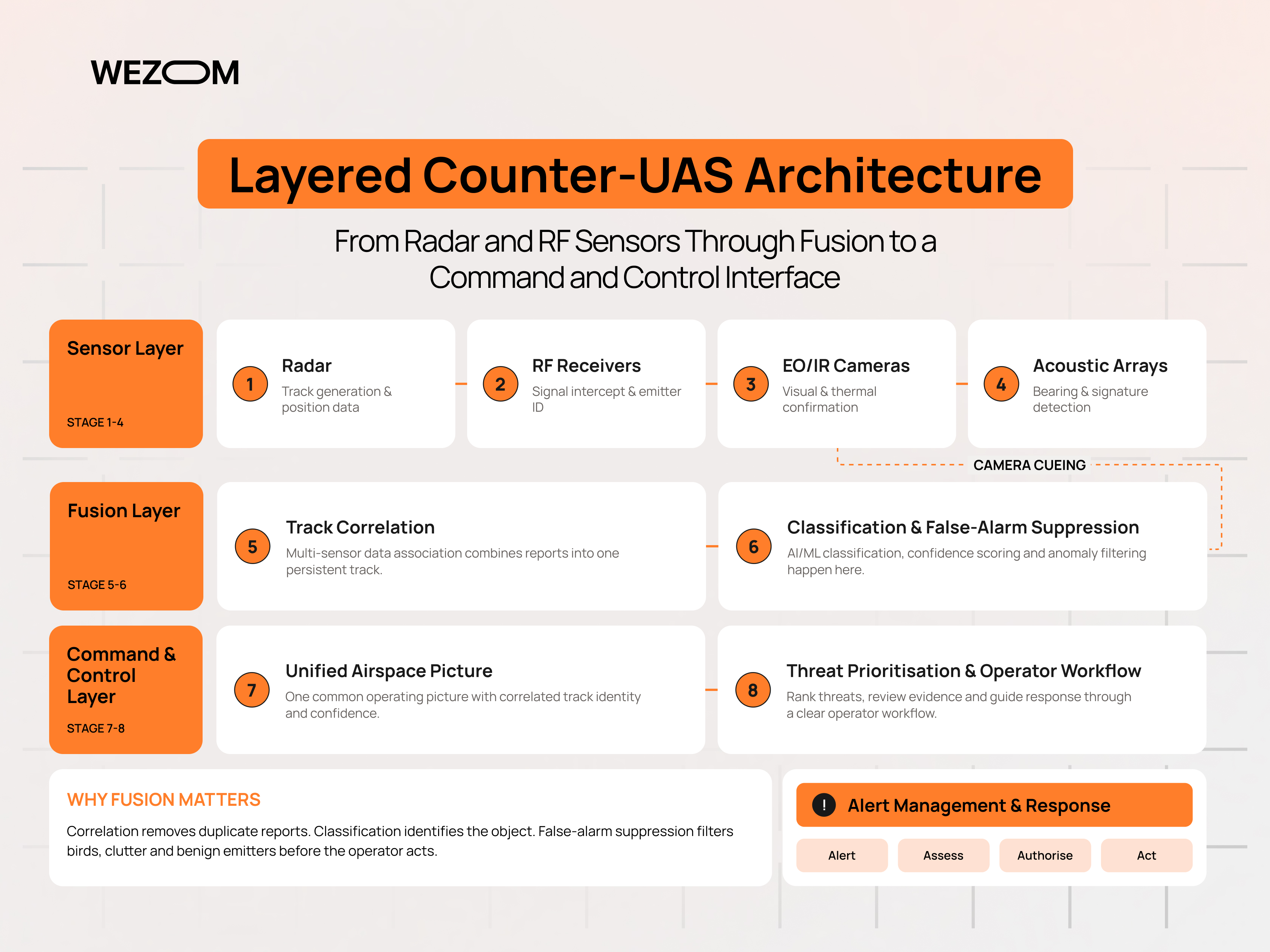
How radar and RF sensors complement each other
The pairing works because the failure modes do not overlap. RF gives early warning and identity, sometimes before the aircraft leaves the ground, while radar gives continuous tracking and covers the silent case. Combining radar and RF drone detection closes both gaps.
Correlating RF signals with radar tracks
Fusion software associates an RF emitter bearing with a radar track occupying the same volume and treats them as one object. Agreement raises confidence and the track inherits model identity, while a radar-only track is flagged as a non-emitting object.
Sensor fusion for improved drone classification
A fused track carries more attributes than either sensor alone: altitude and speed from radar, protocol and model from RF, and behaviour over time. Classification rules can then separate an approved survey flight from an unknown aircraft.
Reducing false positives through multi-sensor correlation
Requiring corroboration before escalation suppresses both dominant nuisance sources. A bird produces a radar track with no RF counterpart and no rotor modulation; a Wi-Fi access point produces an RF signature with no airborne track.
Adding EO/IR cameras for visual identification
Electro-optical and thermal cameras cued by a fused track give visual confirmation, payload assessment, and recorded evidence. Their narrow field of view makes them poor detection sensors, but slewed to known coordinates,s they resolve the friend-or-foe question.
Building a unified C2 interface for detection, tracking, and threat assessment
The command and control platform is where these deployments succeed or fail. It normalises sensor feeds into one airspace picture, applies threat prioritisation rules, holds the incident log, and exposes the workflow telling a security officer what to do next.
When to Choose Radar, RF Detection, or a Hybrid System
RF-first systems for sites dominated by commercial drones
Where the realistic threat is opportunistic operators flying off-the-shelf aircraft, RF gives the best coverage per unit of spend and avoids the permitting overhead of a transmitting sensor. Many corporate campuses and correctional facilities start here.
Radar-first systems for detecting autonomous or RF-silent threats
Where the threat model includes deliberate, planned incursions, radar becomes non-negotiable. Such sites also need precise tracking to cue cameras or authorised effectors, which RF cannot supply.
Hybrid radar-RF systems for high-security environments
Hybrid radar-RF counter-drone systems are the standard answer for airports, defence installations and national infrastructure, where the silent-threat problem and the identification requirement exist simultaneously. These sites also carry the highest cost of a false alarm.
Fixed-site vs mobile counter-drone deployments
Fixed installations allow surveyed sensor positions, permanent power, and calibrated coverage maps. Trailer-mounted configurations trade accuracy for deployment speed, so sensor geometry rather than hardware capability usually limits temporary deployments.
Scaling sensor coverage as the protected perimeter expands
Coverage does not scale linearly. Doubling a protected radius roughly quadruples the area, and terrain masking means additional nodes rarely deliver nominal range, so planning starts from a line-of-sight survey of the actual site.
Counter-Drone Detection by Deployment Environment
Airports and restricted airspace
Airports need warning far enough out to hold departures rather than react to an aircraft over the threshold. Coexistence with existing primary radar and emission constraints near navigation aids make frequency coordination part of the design work.
Critical infrastructure and energy facilities
Substations, refineries and water treatment sites are often unmanned, so detection has to feed a remote security operations centre. Large metal structures create severe reflection and masking problems for both sensor types.
Military bases and defense installations
Threat models here include autonomous and hardened aircraft, so radar leads and RF supports. Requirements typically extend to air-gapped operation and interoperability with existing air defence command systems.
Industrial sites, warehouses, and logistics facilities
Detection at distribution centres is usually driven by theft reconnaissance and unauthorised aerial photography. Dense Wi-Fi raises the RF noise floor, while racking, silos and moving vehicles complicate low-altitude radar coverage.
How small a drone can counter-UAS radar detect?
There is no single answer, because detection depends on radar cross-section, range, altitude and the accepted probability of detection. Small quadcopters present a cross-section in the region of 0.01 m², and detection ranges against them are a fraction of those quoted for larger airframes.
Does RF detection work against frequency-hopping drone signals?
Modern systems handle hopping protocols, since consumer platforms hop by design rather than to evade detection. Wideband receivers observe energy across the whole band and classify the hopping pattern itself. Difficulty rises with non-standard custom links and in congested spectrum.
Can radar and RF detection distinguish drones from birds?
Radar with micro-Doppler processing can, by measuring the modulation that rotating blades impose on the return and separating it from wing beats. Radars without that capability report birds as targets fairly often. RF sensors have no bird problem, since birds emit nothing.
How many sensors are needed to protect a large perimeter?
Node count follows line of sight and terrain rather than perimeter length. A flat, open site may be covered by one or two well-placed radars plus RF receivers, while a heavily built site needs several short-range nodes to overcome masking.
Can an existing counter-UAS platform be upgraded with radar or RF sensors?
Usually, provided the command and control layer supports third-party sensor integration through
Stadiums, public venues, and temporary events
Event security operates on short timelines with dense crowds and saturated spectrum. Rapidly deployable sensors, a pre-event site survey, and a rehearsed escalation procedure matter more than maximum range.
Urban environments with heavy RF and physical clutter
City deployments face multipath that corrupts RF direction finding and buildings that block radar line of sight while generating clutter. Coverage normally means several short-range rooftop nodes rather than one long-range sensor.
Technical Criteria for Selecting Counter-Drone Detection Technology
Required detection and tracking range
Range requirements derive backwards from response time: if a security team needs ninety seconds to act, detection must occur while a drone travelling at 20 m/s is still that far out. Detection range and reliable tracking range differ.
Target drone size, speed, altitude, and radar cross-section
A specification means little without a defined reference target. A range quoted against a 2 kg quadcopter at 100 m altitude tells a different story from one quoted against a fixed-wing UAV, and probability of detection belongs alongside it.
RF frequency coverage and protocol support
Continuous coverage from the low hundreds of megahertz through 6 GHz matters more than library size, because custom builds appear in no library. Worth asking how often signatures update and whether unknown protocols are flagged.
360-degree surveillance and blind-zone requirements
Full azimuth coverage with adequate elevation is the baseline for a site approachable from any direction. Elevation limits leave a cone directly overhead that many radars miss, and staggered placement of several sensors is usually cheaper than one higher-specification unit.
Detection latency and track-update rates
Time from first return to displayed alert determines whether the picture is actionable. Mechanically rotating antennas update on their rotation period, while electronically scanned arrays revisit targets faster, which matters when a target manoeuvres.
API, C2, VMS, and security platform integration
Detection data has value only where it reaches existing operations. Open APIs, video management system integration, and event forwarding into the incident platform should be verified during evaluation, not assumed from a datasheet.
Scalability, maintenance, and total cost of ownership
Ownership cost covers calibration visits, firmware and signature subscriptions, spectrum licences, network bandwidth, and operator time spent handling alerts. Adding nodes later is cheaper when the platform stays vendor-neutral at the sensor layer.
Building a Layered Counter-UAS Detection Architecture
Detection, classification, identification, and tracking workflow
The detection, tracking, and identification sequence defines what each layer contributes: something is present, it is a drone, it is this drone, and this is where it is heading. Problems usually surface at identification, where sensor data becomes an operational decision.
Radar, RF, EO/IR, and acoustic sensor roles
Radar supplies the persistent kinematic picture, RF supplies identity and operator location, cameras supply visual confirmation, and acoustic arrays fill short gaps behind obstructions. Acoustic range spans a few hundred metres, so it supplements the primary layers.
Centralized sensor fusion and threat prioritization
Fusion belongs in one platform holding the site's rules: which zones are protected, which flights are authorised, and what behaviour justifies escalation. Prioritisation should surface a few high-confidence threats instead of every contact.
Connecting detection data with authorized counter-UAS response systems
Mitigation is legally restricted in most jurisdictions, so for many operators the output is a procedural response rather than an effector. Where authorised response exists, the interface must pass a validated track and a record of who authorised the action.
Designing the architecture around site-specific threat models
A credible threat model states who would fly against the site, with what equipment, from where, and to what end. That assessment drives the sensor mix, and revisiting it keeps a deployment useful beyond its first year.
FAQ
Can RF detection locate both the drone and its operator?
Yes, where enough sensors are deployed. A single receiver gives a line of bearing, while three or more time-synchronised units triangulate coordinates for the aircraft and a separate position for the controller. Accuracy depends on sensor geometry, and in dense urban settings reflections can shift the reported operator position significantly.
Can counter-drone radar detect a drone flying without a radio connection?
Yes. Radar detects reflected energy from the airframe, so a pre-programmed, GPS-guided, or fiber-optic drone is detected on the same basis as one under manual control. This is the main reason radar is specified where deliberate incursions form part of the threat model. Documented APIs. Closed platforms that accept only one vendor's hardware make expansion expensive, so checking integration openness before the first purchase keeps a later upgrade a configuration exercise.
