
Do you have to expend a lot of resources maintaining extensive, high-altitude infrastructure, all while risking the lives of your specialists and contending with the human factor? You can resolve this by implementing drone cell tower inspection software that transforms inspections – turning what was once a costly headache into a predictable, fully automated process.
Why Pipeline and Cell Tower Inspections Are Moving From Manual Surveys to Drones
Let’s explore how drone cell tower inspection software optimizes workflows.
Safety Challenges of Inspecting Hard-to-Reach Infrastructure
Sending a high-altitude worker up a 60-meter communications tower or dispatching a crew to marshy terrain along a pipeline always entails risks – such as falls from heights or injuries due to proximity to high-voltage lines. In this context, drone tower inspection software eliminates the need for personnel to be present in hazardous areas.
Limitations of Manual Pipeline Patrols and Tower Climbing
The manual approach is slow and subjective. A single engineer can inspect at most 1-2 towers a day, while a ground-based team covers only a few kilometers of pipeline daily, missing micro-cracks beneath the paint and making errors in their reports.
How UAV Inspection Reduces Downtime, Risk, and Field Work
Using pipeline inspection drones reduces the time required to inspect a site by a factor of 5 to 10, without the need to turn off transmitting equipment. This results in a reduction of up to 70% in costs associated with field visits and specialized machinery.
From Drone Imagery to Actionable Infrastructure Inspection Data
A drone is merely a means of transporting a sensor to the target, while the drone pipeline inspection process itself is automated at the software level, transforming gigabytes of raw photos and video into tower digital twins and orthophotomaps.
How Pipeline Drone Inspection Software Works
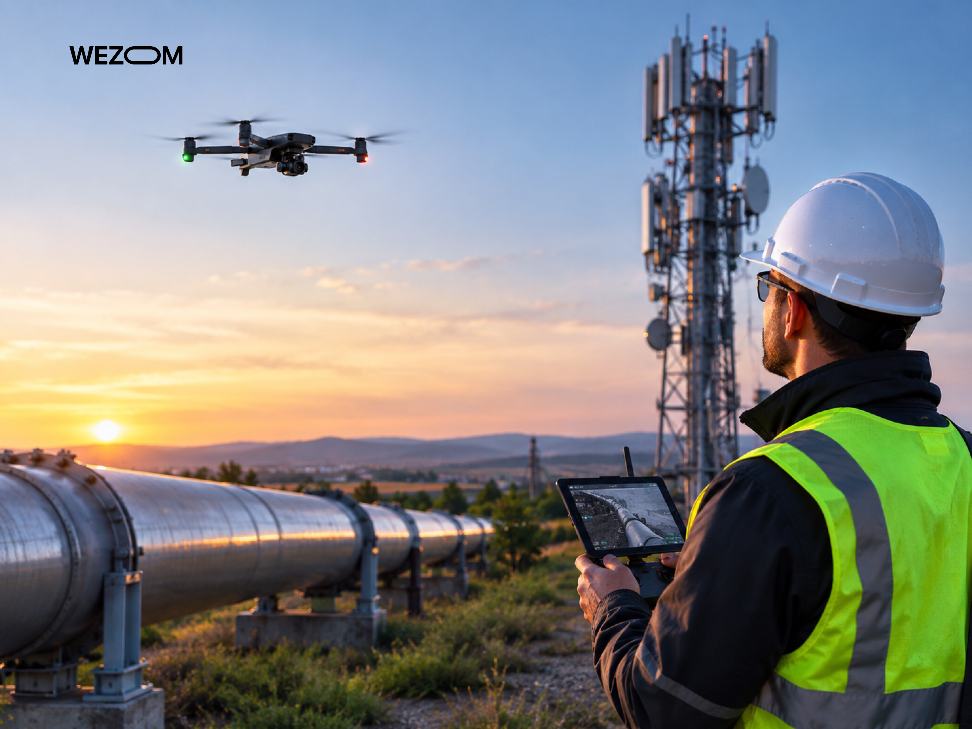
Now, let’s analyze the main principles of drone tower inspection software.
Automated Flight Planning for Pipeline Right-of-Way Inspection
Pipeline inspection software generates 3D flight plans that account for terrain and right-of-way corridors, guiding the UAV along a preset trajectory with fixed image overlap.
Beyond Visual Inspection: Thermal, LiDAR, RGB, and Multispectral Sensors
Drone inspection data management software processes multi-sensor data streams, including RGB (to detect mechanical damage and rust), thermal (to identify localized leaks and equipment overheating), LiDAR (for automated drone inspection of assets obscured by dense vegetation), and multispectral (to assess the condition of underground pipelines).
GPS, RTK, and Geotagged Data for Pipeline Asset Mapping
Data acquisition using RTK/PPK modules ensures unprecedented positioning accuracy for every frame, facilitating the overlay of imagery from different years (here, we mean drone 3D mapping) to reconstruct the chronological condition of assets.
AI-Powered Pipeline Leak and Anomaly Detection
AI infrastructure inspection platform with regular retraining highlights defects in real time, prioritizing them based on severity.
Detecting Corrosion, Vegetation Encroachment, and Third-Party Activity
Corrosion is identified using computer vision, vegetation encroachment via LiDAR drone inspection, and unauthorized activity through artificial intelligence.
Methane and Gas Leak Detection With Drone Inspection Systems
Methane detection drone laser scanners and OGI thermal imaging sensors can identify minute concentrations of flammable gases, transmitting an alert to the operator along with the GPS coordinates of the leak site.
Creating GIS-Ready Maps and Digital Records From Pipeline Drone Data
The cell tower inspection software outputs data in Shapefile/GeoTIFF/LAS formats. It must also be designed for seamless integration with enterprise systems.
Drone Cell Tower Inspection Software: From Automated Flights to Digital Twins
Traditional methods require engineers to frequently climb to heights, whereas cell tower drone inspection software digitizes the process, thereby reducing the time required to audit a single tower from several hours to 10-20 minutes.
Autonomous Flight Paths Around Telecom Towers
The critical infrastructure inspection software can calculate an adaptive spiral or circular flight path around the tower, taking into account its geometry and height, while ensuring safe autonomous drone inspection and preventing collisions.
High-Resolution Image Capture for Antennas, Cables, Mounts, and Structural Components
An ultra HR camera captures equipment serial numbers, the condition of cable runs, grounding status, and other factors, while the software itself handles real-time frame overlap monitoring.
Photogrammetry and 3D Reconstruction for Cell Tower Inspection
Photogrammetry algorithms combine images into a point cloud and a 3D model. As for reconstruction automation, the software accounts for the specific characteristics of lattice structures, preventing visual distortion of fine details.
Cell Tower Digital Twins for Remote Engineering and Asset Management
Cell tower digital twins allow engineers to measure distances and plan equipment placement within a browser, thereby eliminating the need for repeated site visits.
Measuring Antenna Azimuth, Downtilt, Height, and Equipment Position
The software automatically determines the spatial parameters of the antennas, including azimuth, tilt angle, mounting height, and position relative to the tower axis.
Comparing As-Built Tower Conditions With CAD and Engineering Designs
The software must be capable of comparing the as-built digital twin with CAD drawings and design documentation to timely identify unauthorized equipment installations or, for instance, the overloading of load-bearing structures.
5G Deployment and Telecom Site Audit Applications
5G software accelerates the pre-engineering site audit process, helping to determine available space on antenna sectors and prepare precise specifications for installation crews.
Main Features of Drone Tower Inspection Software
In this paragraph, we’d like to consider the features of pipeline corrosion detection solutions.
Mission Planning and Automated Drone Navigation
The planning module enables consolidating the coordinates of thousands of towers and generating missions that take into account local topography, satellite coverage areas, and no-fly zones.
AI Computer Vision and Automated Defect Detection
AI defect detection algorithms can instantly find signs of corrosion, cracks, loose bolts, cable insulation damage, and other issues.
Image Annotation and Georeferenced Inspection Findings
The drone leak detection software links each issue to spatial coordinates on the 3D model and generates a markup plan with annotations and criticality levels.
3D Models, Point Clouds, and Photogrammetry Processing
The cloud server transforms raw frames into point clouds and polygonal meshes, which can be immediately exported to BIM/CAD systems.
Thermal Imaging and Sensor Data Analysis
Combining radiometric thermal imaging data with photographs accelerates the detection of overheating in RRUs and distribution panels.
History of Evaluation and Variation in the Time Between the Flights
The function of time analysis processes two samples together, illustrating the developments made by corrosion and the emergence of new items.
Automated Reporting and Engineering Outputs
Reports may be produced and saved in the PDF/Excel format, including defects in orthoimages.
Unified Dashboard for Asset Portfolio of Infrastructure
The dashboard combines data and shows the defects’ severity and repairs’ dynamics.
AI-Powered Drone Inspection Analytics for Pipeline and Telecom Assets
Inspecting extensive or high-rise structures requires making well-founded engineering decisions. This is achieved through the implementation of the following features.
Computer Vision Models for Infrastructure Defect Recognition
Neural networks trained on millions of annotated frames instantly detect defects and damage with up to 98% accuracy, ignoring glare and image noise.
Automatic Asset and Equipment Identification
AI algorithms can segment antennas, RF units, feeders, supports, compensators, safety zone markers, and other elements.
Severity Classification and Inspection Finding Prioritization
Each detected defect can be automatically classified according to a risk matrix, helping technical teams to quickly generate repair lists and schedule work crew deployments.
Detecting Changes Between Recurring Drone Inspections
The spatiotemporal comparison function matches images from previous overflights, highlighting ground subsidence, the development of corrosion, the emergence of new vegetation, equipment displacement, and more.
Predictive Maintenance Using Historical Inspection Data
Analyzing material degradation rates and cumulative data from previous inspections enables the software to identify potential points of failure, thereby introducing a proactive maintenance model.
Human-in-the-Loop Validation for Critical Infrastructure Findings
To prevent false positives, a rapid validation interface based on the "human-in-the-loop" principle is typically used, which enables the model to undergo gradual retraining.
Pipeline Drone Inspection vs. Cell Tower Drone Inspection
Let’s check the differences between these two scenarios involving drones.
Linear Infrastructure Inspection vs. Vertical Asset Inspection
Linear assets such as pipelines require constant speed and long-range operation while accounting for no-fly zones, whereas communication towers require precise spatial positioning and flight paths that orbit the structure in a spiral/spherical pattern.
Differences in Flight Planning and Autonomous Navigation
In the case of pipeline navigation it is crucial to stick to the topography, while flying around towers requires the implementation of adaptive flight-around process keeping a fixed distance from the object and adjusting flight considering wind blows.
Sensor Requirements for Pipelines and Telecom Towers
Pipeline inspections involve the use of RGB cameras, LiDAR, thermal imagers, and gas analysis sensors, whereas inspections of telecommunications towers typically employ high-resolution optics with an 85-100 mm focal length for detailed imaging of fasteners, as well as radiometric thermal imaging under load.
Pipeline Leak Detection vs. Tower Structural Defect Detection
For pipelines, the priority is detecting physical leaks and third-party excavation activities, whereas for towers, the focus is on checking structural integrity, corrosion, antenna tilt angles, and static loads.
Comparing Data Processing, 3D Modeling, and Reporting Workflows
Pipeline data processing is based on the generation of long-strip orthophotos and digital terrain models, while tower data is processed into 3D point clouds and/or digital twins for CAD/BIM platforms.
Drone Inspection Software Architecture and Data Workflow
Now, let’s examine the architecture of such software and how data moves through it.
Drone and Sensor Data Collection Layer
This level integrates with popular industrial UAV firmware and multispectral payloads, ensuring georeferenced metadata streaming.
Edge Processing vs. Cloud-Based Drone Data Processing
Initial filtering and anomaly detection can be performed on a field terminal, while photogrammetric modeling and in-depth analytics are uploaded to the cloud.
Photogrammetry, Point Cloud, and Digital Twin Processing
The cloud pipeline automatically scales computing resources to generate accurate orthophotos and point clouds.
AI Analytics and Computer Vision Pipeline
Each uploaded frame passes through neural networks that handle everything: identifying the equipment type, assessing micro-defects, spatially referencing detected issues, and so on.
Inspection Management and Asset Database
A centralized database stores a tree of infrastructure objects that the user can access to review the history of spans, defects, repairs, and so on.
APIs for Connecting Drone Inspection Software With Enterprise Systems
Open REST APIs enable integration with enterprise systems to synchronize object statuses and reporting.
Integrating Drone Inspection Data With Existing Infrastructure Management Systems
Now, a few words about integrations.
GIS Integration for Pipeline Inspection and Asset Mapping
Results can be exported to ArcGIS, QGIS, or other systems using Shapefile/KML/GeoTIFF formats.
CMMS and Enterprise Asset Management Integration
The software must be capable of interfacing with EAM/CMMS systems, enriching the asset record with up-to-date data.
Connecting Inspection Findings With Maintenance Work Orders
Upon detecting a critical defect, the system must be capable of automatically generating a draft work permit or a repair request, complete with GPS coordinates and photos.
CAD and BIM Integration for Tower Engineering Workflows
Exporting point clouds in LAS/E57 formats and simplified 3D models in DWG/IFC enables engineers to load tower digital twins into Revit/Tekla/AutoCAD.
API Integration With Telecom and Oil & Gas Platforms
Connectors organize data exchange with industry-specific network infrastructure management platforms.
Exporting Inspection Reports, Images, Point Clouds, and Geospatial Data
The user must be able to export data in PDF/JSON/CSV/LAS/GeoTIFF formats.
Building Custom Pipeline Drone Inspection Software
As a development company, we create an architecture that transforms raw UAV data into high-precision analytics.
Defining Inspection Use Cases, Assets, and Defect Taxonomy
We formalize the asset tree and the defect classifier, creating a unified context for machine learning.
Selecting UAV Platforms, Cameras, and Inspection Sensors
The software architecture is designed to accommodate high-resolution optical cameras, thermal imagers, LiDAR, laser methane analyzers, and other sensors, while taking into account the specific characteristics of various UAV platforms.
Developing Autonomous Pipeline Flight Planning
The mission planning module generates low-altitude corridor routes featuring terrain-following capabilities and a safe return function for the UAV.
Building AI Models for Leak, Corrosion, and Anomaly Detection
Custom computer vision models are trained on specialized datasets to detect ground shifts, temperature anomalies, corrosion, and the like.
Developing GIS-Based Pipeline Inspection Dashboards
The geoinformation dashboard displays the condition of hundreds of kilometers of the route on an interactive, spatially referenced map.
Creating Mobile and Web Applications for Field Inspection Teams
Cross-platform applications enable field crews to receive repair assignments complete with precise GPS coordinates and visual aids.
Developing Custom Drone Cell Tower Inspection Software
Now, we propose to consider the process of custom telecom tower inspection software development.
Designing Automated Tower Orbit and Capture Missions
Algorithms calculate a spiral or cylindrical flight path around the tower, taking into account the safe distance and image overlap requirements.
Building Telecom Equipment Recognition With Computer Vision
Neural networks recognize and inventory antenna types, RF units, feeder lines, and grounding elements.
Creating Cell Tower 3D Models and Digital Twins
A cloud-based photogrammetry pipeline transforms images into point clouds and digital twins for subsequent analysis.
Developing Automated Antenna Measurement Tools
The UAV tower inspection software measures azimuth, downtilt, antenna mounting height, and other parameters to compare them with those specified in the design documentation.
Building Defect Annotation and Engineering Review Workflows
The interface allows engineers to validate AI insights, add comments, change statuses, generate defect lists, and more.
Managing Thousands of Cell Tower Inspections From One Platform
A hierarchical database aggregates data from thousands of objects, tracking the dynamics of their changes.
Data Accuracy, Security, and Compliance for Critical Infrastructure Drone Inspections
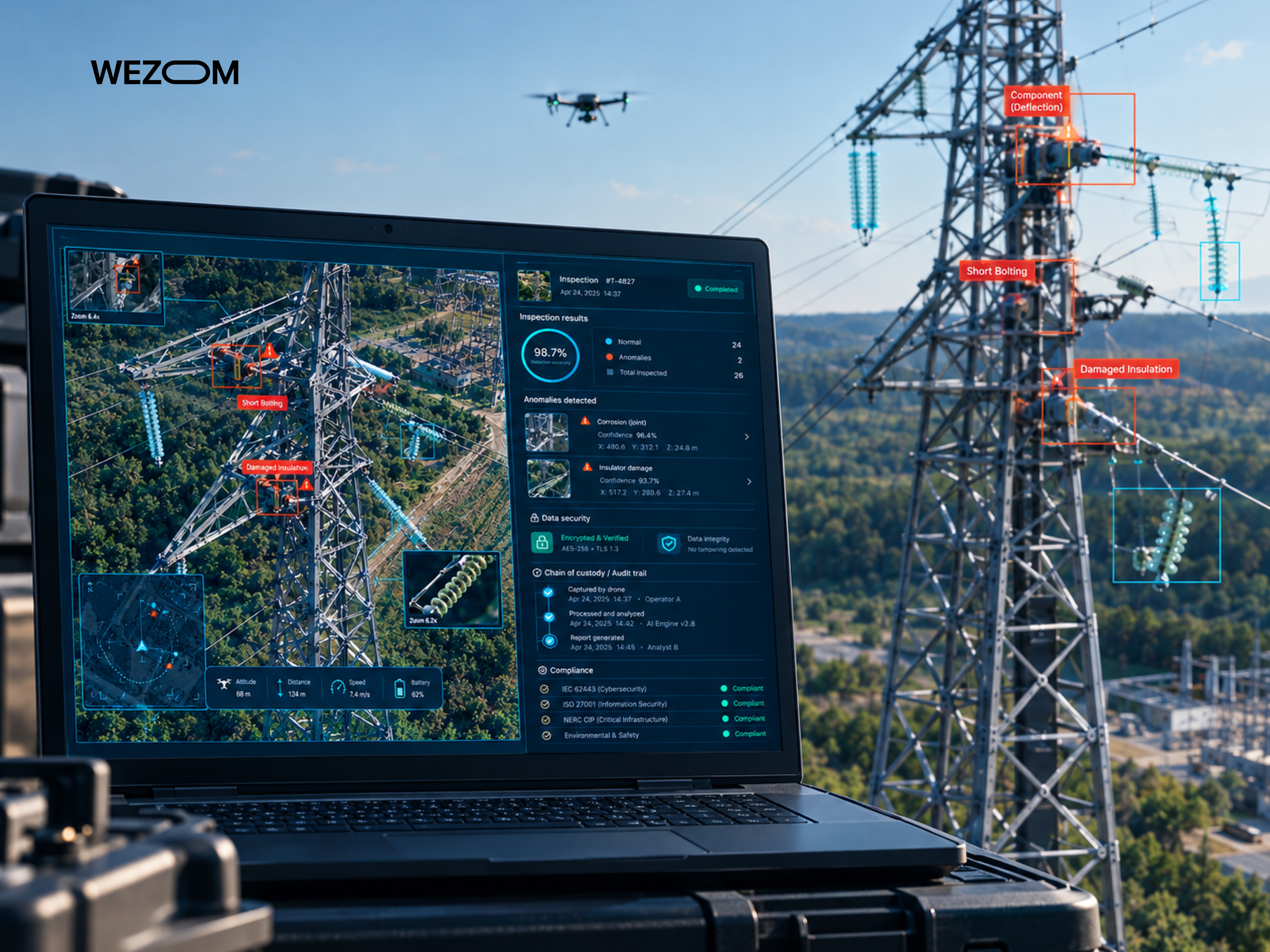
Let’s analyze the main requirements for tower inspection software.
Maintaining Consistent Image and Sensor Data Quality
Automatic image validation during upload filters out blurred frames and incorrect metadata, guaranteeing high drone inspection analytics accuracy.
RTK and PPK Positioning for Accurate Infrastructure Mapping
Integration with RTK/PPK modules ensures centimeter-level georeferencing accuracy, which is a must-have when overlaying imagery from different years.
Securing Drone Inspection Images and Critical Asset Data
Critical infrastructure data must undergo TLS/AES-256 encryption at all stages and be stored in isolated cloud/on-premises environments.
Access Control, Audit Trails, and Inspection Data Governance
A role-based access model and logging of all actions ensure that every operation is recorded.
Operating Drones Around Pipelines and Telecom Infrastructure
The drone photogrammetry software must account for electromagnetic interference and the specific conditions of areas near pipelines by establishing safe buffer zones.
Building Software Around Regional UAV Regulations and Flight Restrictions
The flight planning module must be capable of cross-referencing no-fly zone databases and regional flight requirements.
How to Choose Drone Inspection Software for Pipelines and Cell Towers
Here are the criteria for evaluating infrastructure inspection software platforms.
Asset Type and Inspection Coverage Requirements
The drone inspection software must support capturing extensive linear assets and tall structures with millimeter-level detail.
Autonomous Flight and Mission Planning Capabilities
The cell tower inspection drone system must automatically generate 3D flight paths that account for terrain contours and maintain a constant distance from the assets.
Supported Sensors and Drone Hardware
The pipeline monitoring drone platform must be vendor-agnostic and process data from RGB cameras, LiDAR, thermal imagers, and gas analyzers.
AI Defect Detection and Analytics Requirements
Computer vision algorithms must detect corrosion, displacements, cracks, and leaks.
Digital Twin and 3D Modeling Capabilities
The UAV pipeline inspection software must generate photogrammetric 3D models and point clouds to enable browser-based measurements.
Integrations with GIS, CAD, CMMS, and Asset Management
The pipeline inspection UAV solution must be predisposed to integration with ArcGIS/SAP/IBM Maximo/AutoCAD for automated reporting.
Cloud, Edge, Hybrid, and On-Premise Deployment
The drone infrastructure inspection platform’s architecture must support hybrid and on-premises deployment in compliance with security standards.
Scalability for Large Pipeline Networks and Tower Portfolios
The thermal drone inspection system must rapidly process thousands of assets, handle gigabytes of imagery, and support database searches by default.
Custom Software vs. Off-the-Shelf Drone Inspection Platforms
Off-the-shelf drone asset inspection platforms handle standard tasks, whereas custom telecom tower drone inspection development can implement AI algorithms tailored to specific business needs.
Business Impact of Pipeline and Tower Inspection Automation
The following section outlines the main business benefits of transitioning to pipeline right-of-way inspection systems.
Reducing Human Exposure to Hazardous Inspection Environments
Automation eliminates up to 90% of hazardous work at heights and minimizes human presence in high-risk zones.
Increasing Inspection Frequency Without Expanding Field Teams
A single pipeline leak detection drone operator can replace multiple field crews, enabling a shift from annual to monthly inspections.
Moving From Periodic Inspections to Condition-Based Maintenance
Asset maintenance shifts from a rigid schedule to a model based on the actual physical condition of the structures.
Creating Consistent Digital Inspection Records Across Asset Portfolios
All data is collected according to a unified standard with precise georeferencing, creating a transparent operational history.
Turning Drone Data Into Maintenance and Engineering Decisions
Images are automatically converted into defect logs that include criticality priorities and repair scope estimates.
The Next Generation of Autonomous Infrastructure Inspection
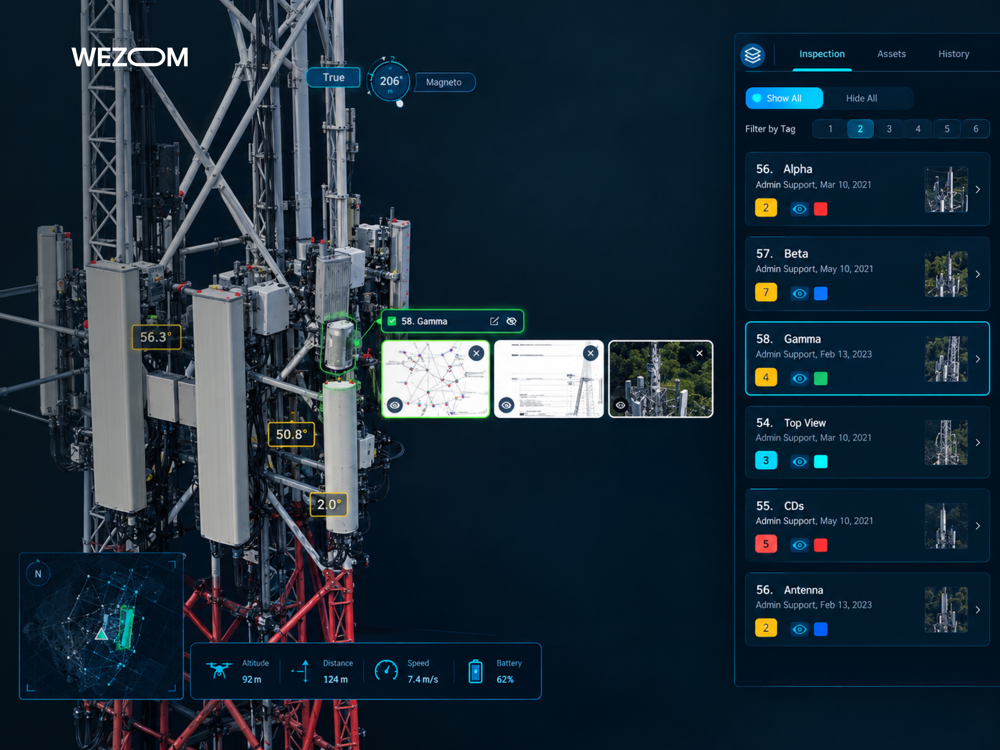
Let’s consider the technological trends defining the future of autonomous pipeline drone inspection monitoring.
Drone-in-a-Box Systems for Recurring Asset Inspections
Autonomous drone-in-a-box systems enable scheduled inspections without the need for an on-site pilot, while handling automatic recharging and cloud-based data transmission.
BVLOS Operations for Long-Distance Pipeline Monitoring
Beyond-Visual-Line-of-Sight flights, combined with satellite connectivity and automated mission planning, enable the continuous monitoring of hundreds of kilometers of pipeline infrastructure.
AI Agents and Automated Inspection Data Processing
Multimodal AI drone inspection agents handle the imagery sorting and automatically generate technical reports and repair recommendations.
Digital Twin Updates From Recurring Drone Flights
Each repeat flight automatically updates the digital twin’s data layers, highlighting the slightest changes in geometry or material condition.
Predictive Infrastructure Maintenance With AI and Drone Data
By correlating structural degradation patterns with weather conditions and service life, neural networks can predict potential equipment failure dates.
Combining Drones, IoT Sensors, and Enterprise Asset Intelligence
Data from drone inspections is integrated with readings from various sensors, creating an ecosystem for digital asset management.

FAQ
How much data does a typical drone infrastructure inspection generate?
A comprehensive inspection of a cell tower generates 3-8 GB of data (300-600 high-resolution photos). Inspecting 10 km of pipeline using multispectral cameras and LiDAR generates 15-40 GB of raw data.
Can drone inspection software work with multiple drone manufacturers?
Yes, professional pipeline drone inspection software is designed to be hardware-agnostic. It supports data and geospatial metadata processing from UAVs from DJI, Autel, Skydio, Wingtra, etc.
Can existing historical inspection images be imported into a drone inspection platform?
You can upload archival photos, orthomosaics, reports, point clouds, and 3D models to correlate them with new data using geotags and timelines for comparative analysis.
How often should pipelines and cell towers be inspected with drones?
Cell towers are typically inspected once or twice a year or prior to the installation of new equipment. Pipeline rights-of-way require basic overflights once or twice a month, while critical sections require weekly inspections.
Can drone inspection software operate without continuous internet connectivity?
Yes, field applications operate in offline mode, saving images and flight logs locally on the device and synchronizing them once a network connection is established.
How long does it take to train an AI model for a specific infrastructure defect?
Training a base model on an existing dataset takes 2 to 4 weeks. Fine-tuning a model for a non-standard defect requires 1,000-3,000 annotated frames and approximately 1-2 months of work.
Can one drone inspection platform manage both pipeline and telecom assets?
Yes, the drone tower inspection software architecture supports multi-type asset structures and employs specific flight modules and processing algorithms for each distinct object type.
What data should be retained after a drone inspection mission?
Mandatory retention applies to raw imagery with EXIF metadata, classified point clouds, 3D models/orthomosaics, and reports on identified defects with annotations.
