
A single inspection flight can produce thousands of full-resolution images, gigabytes of video, and a continuous telemetry stream, yet none of it becomes useful until something interprets it. The gap between capture and decision is where most UAV programs stall: media lands in a folder, an analyst reviews it days later, and the crew that could have acted on the finding has already left the site. Real-time drone data analysis closes that gap by moving detection, measurement, and alerting closer to the moment of capture. What follows covers the processing pipeline, the software stack, the choice between edge and cloud, integration with operational systems, and how to evaluate a platform.
How Real-Time Drone Data Analysis Turns Raw UAV Data Into Decisions
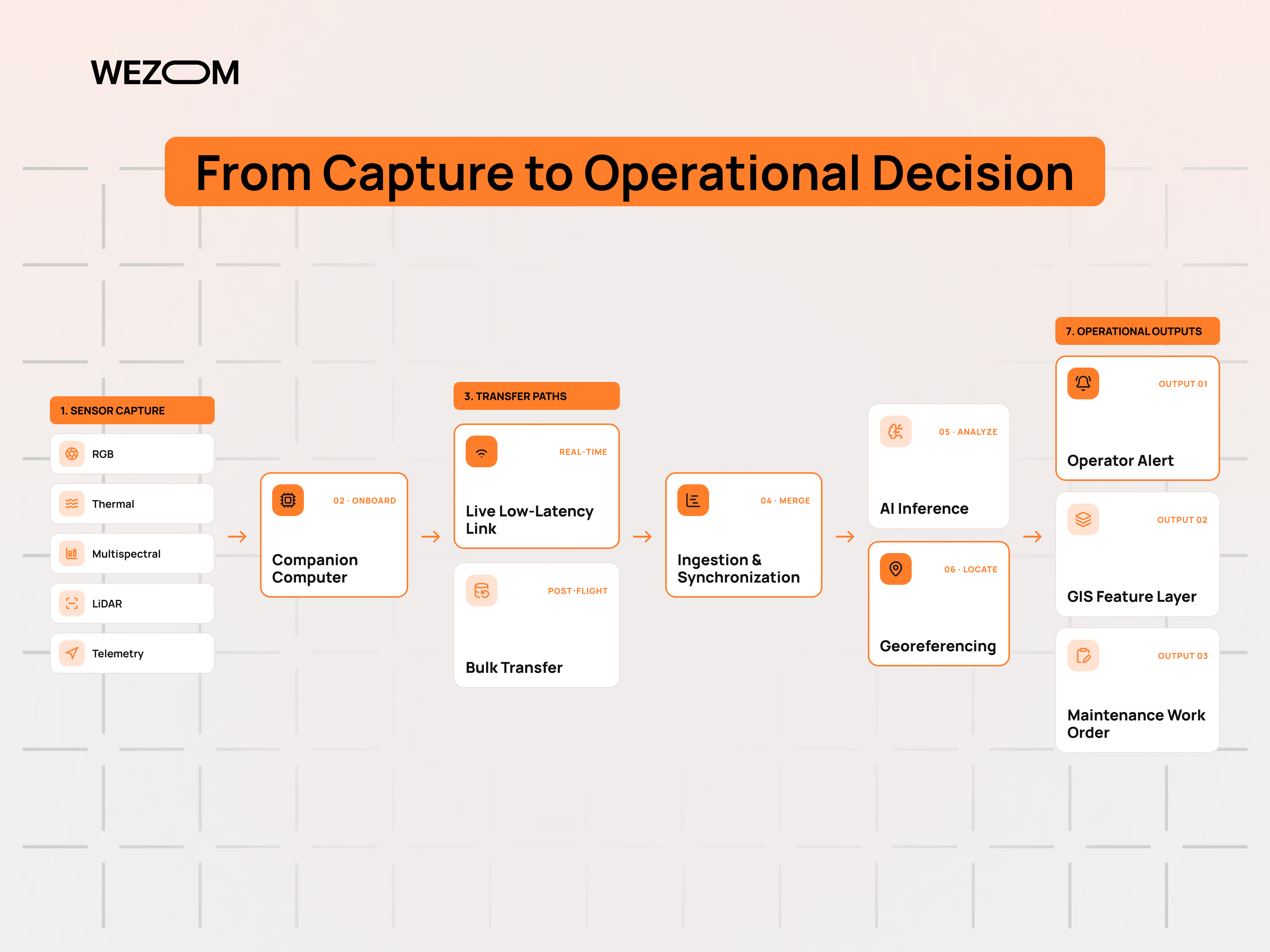
What drone data can be analyzed in real time: imagery, video, LiDAR, thermal, multispectral, and telemetry
Each payload produces a different analytical product. RGB stills support photogrammetry and defect detection, while a live H.264 or H.265 video feed supports tracking and visual triage. Radiometric thermal frames carry per-pixel temperature, making overheating connections and insulation loss detectable during the flight itself. Multispectral bands feed vegetation indices such as NDVI and NDRE, and LiDAR returns geometry rather than appearance. Drone telemetry data from the flight controller supplies the GNSS position, attitude, and timestamps that place every other stream correctly on the ground.
The data pipeline from drone capture to actionable insight
The sequence is consistent across platforms. Sensors capture, an onboard computer buffers and optionally compresses or filters, a radio or cellular link transports the result, an ingestion service timestamps and aligns it, inference produces detections or measurements, and a georeferencing step converts pixel coordinates into map coordinates. Only after that step does output become operational, because a defect without a location cannot be dispatched to a crew.
Real-time vs near-real-time vs post-flight drone data processing
Real-time means the result is available while the aircraft is airborne and can change the mission, which requires onboard inference or a low-latency link. Near real time places results in front of an operator within minutes, usually after an edge device uploads at the end of a pass. Post-flight drone data processing covers photogrammetry, dense point clouds, and precise reconstruction, which remain batch jobs. Most programs run all three modes rather than choosing one.
Drone Data Analytics Software: Core Components of the Technology Stack
Data ingestion and synchronization across UAV sensors
Sensors sample at different rates and rarely share a clock. Ingestion services normalize this by stamping every frame against GNSS time, interpolating IMU and position records to each exposure, and buffering packets that arrive out of order after a link drop. Message brokers such as MQTT or Kafka sit between the aircraft and the processing tier, so an outage delays analysis instead of destroying the record.
AI and computer vision for object detection, classification, and anomaly detection
Detection models locate objects and defects within a frame, classification assigns them to categories such as corrosion or vegetation encroachment, and segmentation supports area measurement. Computer vision models are usually trained on the operator's own imagery, since altitude, camera geometry, and lighting differ enough between programs that generic weights underperform. Anomaly detection covers what supervised models miss, flagging frames that deviate from an asset class's expected appearance.
Geospatial processing, mapping, and GIS visualization
Geospatial data processing converts detections into features with coordinates in a reference system the organization already uses. Orthomosaics, digital surface and terrain models, and classified point clouds are the standard cartographic products. Publishing them through OGC services or cloud-optimized GeoTIFF and STAC catalogs lets analysts open aerial imagery processing results alongside cadastral, network, and asset layers without manual file transfers.
Dashboards, alerts, reporting, and automated decision workflows
A dashboard shows the flight track, detections, and their severity on a map, while an alerting layer decides which warrant interruption. Thresholds are typically set per asset class rather than globally, because a temperature delta that is routine on one component is serious on another. Reporting then produces the inspection record regulators, insurers, or clients require.
Cloud-based vs edge-based drone analytics platforms
Cloud drone processing centralizes storage, model training, and cross-site comparison, and scales without capital hardware. Edge platforms run inference on the aircraft or a ground station and stay usable where connectivity does not reach. The distinction is less about capability than about where the delay sits: cloud analysis waits for upload, edge analysis is limited instead by the compute an airframe can carry.
Edge Computing for Real-Time Drone Data Analysis
Processing drone imagery and video directly onboard the UAV
Onboard drone processing runs on a companion computer wired to the camera and flight controller, commonly an embedded GPU or NPU module of the Jetson or Qualcomm class. The workload is deliberately narrow: decode frames, run a quantized model, discard frames containing nothing of interest, and forward the rest with metadata. Payload mass and power draw constrain what can be installed, since every watt spent on compute reduces endurance.
How edge AI reduces latency and bandwidth requirements.
Transmitting raw 4K video consumes far more link capacity than transmitting the few frames that contain something. Edge AI inverts that ratio by sending detections, image crops, and coordinates instead of the full stream, which keeps operations viable on constrained LTE uplinks. Latency falls for the same reason: the decision no longer depends on a round trip to a data center.
Cloud, edge, and hybrid drone data processing architectures
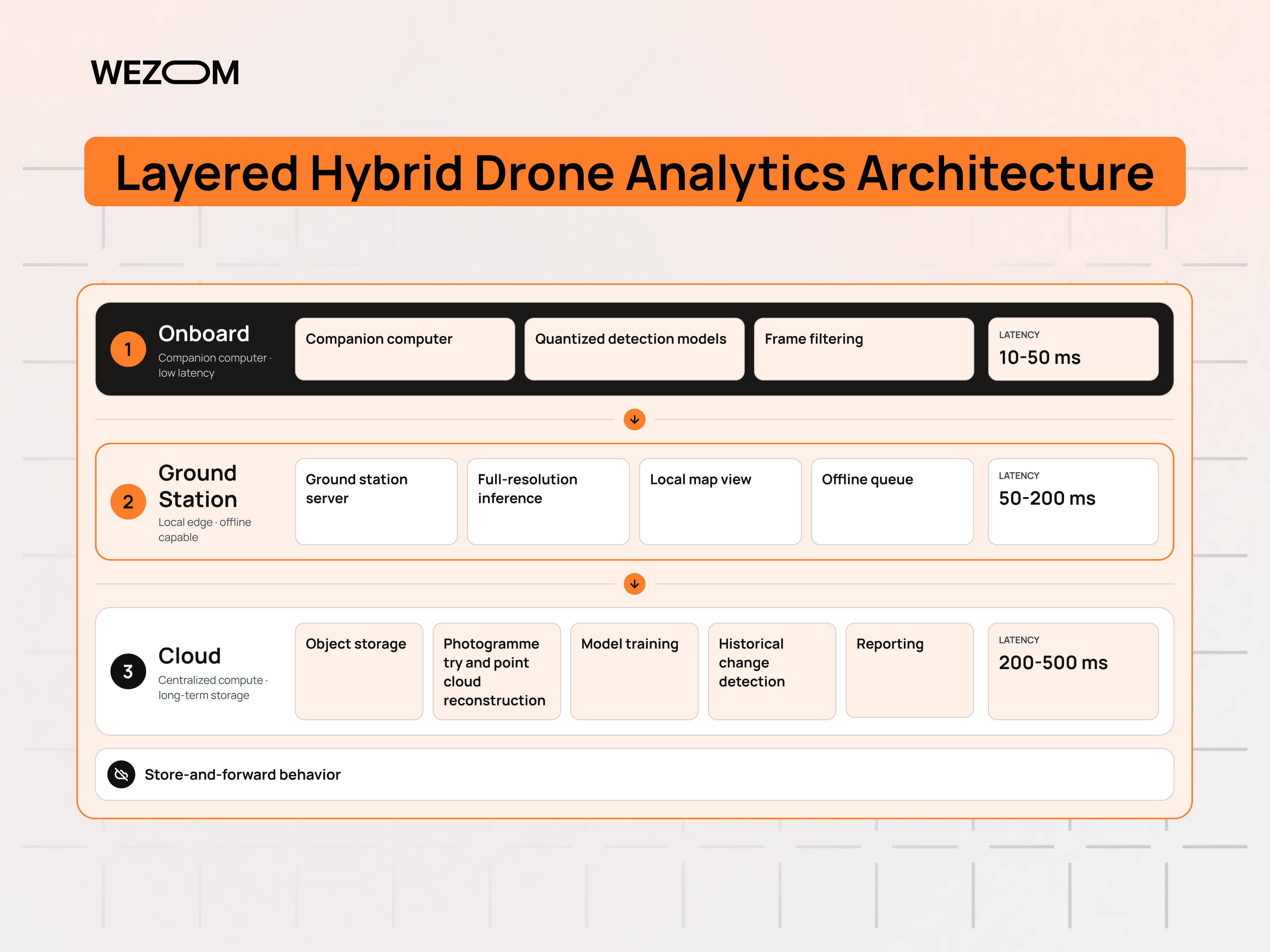
Hybrid is the common production pattern. The aircraft performs triage and time-critical detection, a ground station or local server handles heavier inference during and immediately after the flight, and the cloud stores everything, runs photogrammetry, retrains models, and serves historical comparison. Splitting the pipeline this way also isolates failure: a lost cloud connection degrades reporting rather than stopping the inspection.
Connectivity considerations: Wi-Fi, LTE, 5G, satellite, and offline environments
Wi-Fi links suit short-range work near a ground station and degrade quickly with distance and obstruction. LTE and 5G extend range wherever coverage exists and support beyond-visual-line-of-sight operations subject to national rules, with 5G offering the uplink capacity video analytics needs. Satellite links cover remote corridors at higher latency and cost. Offshore platforms, underground sites, and disaster zones often have no usable network, so the software must queue results locally and reconcile them on reconnection.
Drone Data Integration With Existing Business and Operational Systems
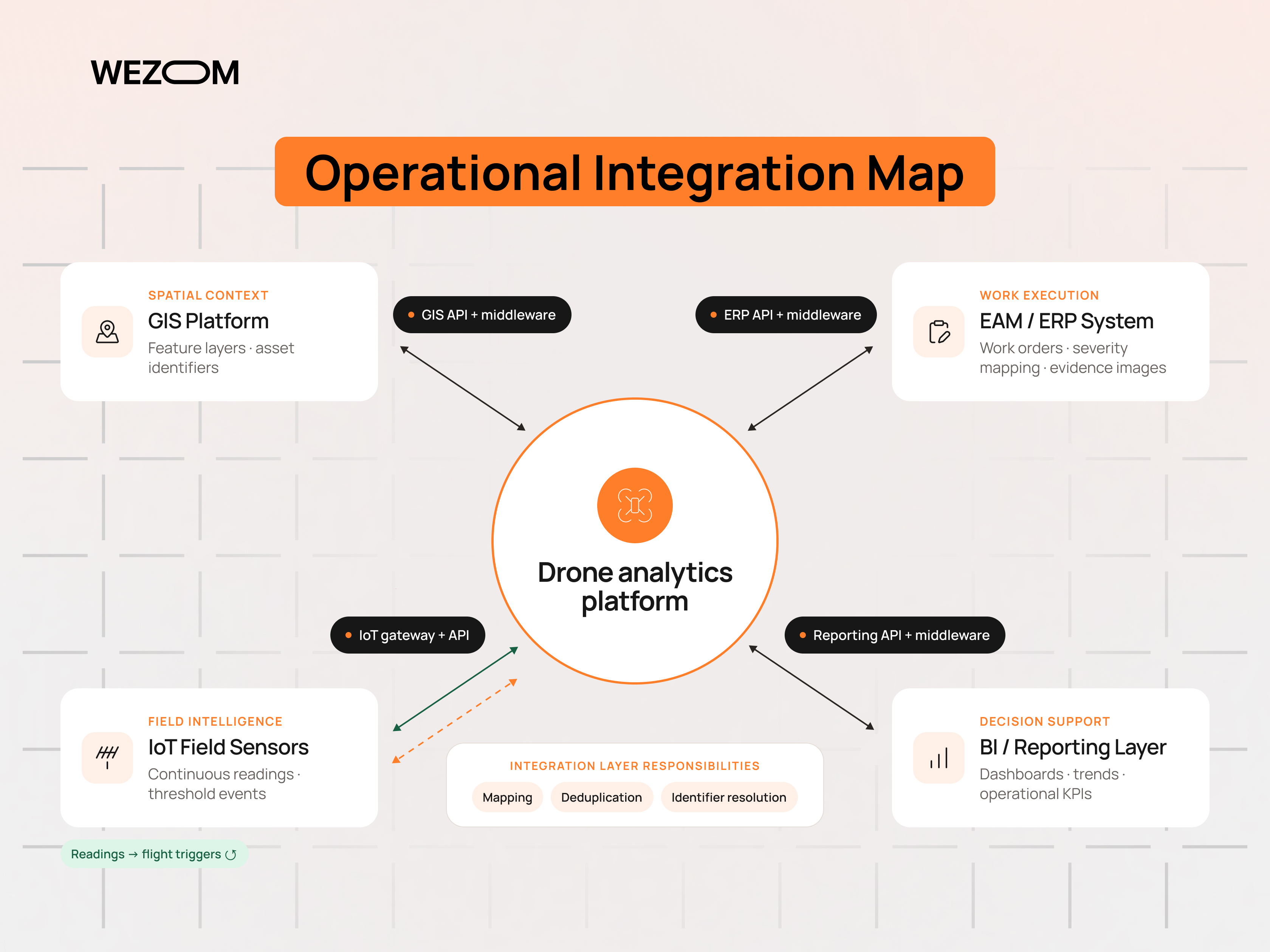
Drone data integration is where a program becomes operational or remains a pilot, because insight that stays inside the analytics platform never reaches the people who act on it.
Drone data integration with GIS and geospatial platforms
GIS integration is usually the first connection built, since the organization already models its assets spatially. Detections publish as feature layers keyed to existing asset identifiers rather than as standalone files, so a flagged insulator resolves to a known structure in the network model. Reprojection and datum handling matter here, because a survey delivered in the wrong reference frame appears as a systematic positional offset.
Connecting UAV analytics to ERP, asset management, and maintenance systems
Operational value appears when a detection creates a work order. An integration layer maps severity to a maintenance priority, attaches the georeferenced image as evidence, and writes the record into the EAM or ERP system so that scheduling, parts, and crew assignment follow the existing process. Deduplication is essential, since repeat flights detect the same defect again and again.
APIs, SDKs, webhooks, and data pipelines for drone software integration
Vendor SDKs expose flight control and payload access on the aircraft side, while REST or GraphQL APIs expose missions, media, and analysis results on the platform side. Webhooks are the practical mechanism for real-time handoff, pushing a detection event to a downstream system rather than requiring it to poll. For bulk transfers, object storage with event notifications generally outperforms drone API integration through paginated endpoints.
Integrating drone analytics with IoT sensors and other field data sources
Aerial observation is periodic while fixed IoT sensors are continuous, and combining them narrows uncertainty. A vibration or temperature sensor reporting an anomaly can trigger a flight, and the imagery confirms or dismisses the suspected cause. Correlating the two requires a shared asset identifier and aligned timestamps rather than a shared dashboard.
Data formats, interoperability, and synchronization challenges
Drone output arrives as a mix of GeoTIFF, LAS or LAZ point clouds, radiometric JPEG, proprietary flight logs, and vendor-specific analysis exports. Converting on ingestion into a small set of canonical formats prevents every downstream tool from implementing its own parser. Synchronization problems usually trace back to clock drift or partial uploads, both cheaper to catch at ingestion than after a report is published.
From Computer Vision Output to Actionable Drone Intelligence
Converting detections and measurements into operational alerts
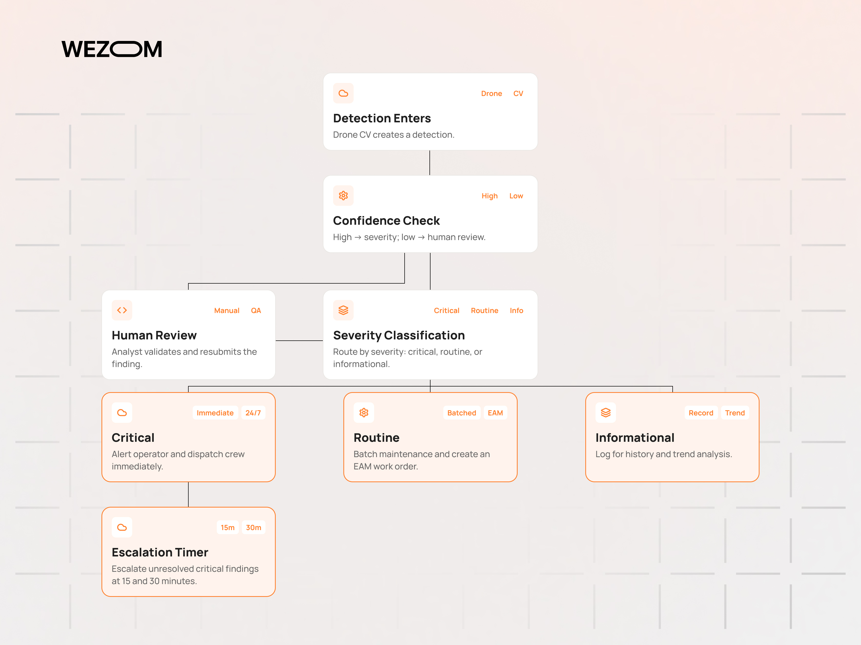
A raw detection carries a class, a confidence score, and a bounding box. Turning it into an alert requires three additions: a position on the asset, a severity derived from measured quantities such as temperature delta or crack width, and a rule that decides who is notified. Without severity logic, high-recall models generate more automated alerts than any inspection team can triage.
Automated anomaly detection and condition monitoring
Condition monitoring compares an asset against its own history rather than against a fixed threshold. A thermal signature that has risen steadily across four consecutive surveys is more informative than any single reading. This depends on stable flight paths and consistent capture parameters; otherwise, apparent change reflects a different viewing angle rather than a changed asset.
Geolocation, change detection, and spatial analytics
Geolocation projects an image detection onto ground coordinates using camera intrinsics, attitude, and a terrain model, with RTK or PPK positioning where accuracy requirements are tight. Change detection then aligns repeat surveys and computes differences: volume moved on a site, vegetation growth into a corridor, or displacement of a structure. Spatial analytics turns those differences into queries such as which assets exceed a clearance limit.
Building automated workflows around drone-generated insights
Once alerts carry severity and location, routing becomes deterministic. A workflow engine dispatches critical findings immediately, batches routine ones into a scheduled maintenance package, and escalates anything unresolved after a defined interval. Encoding these rules in the platform rather than in operator habit is what makes results reproducible across sites and crews.
Human-in-the-loop validation for high-impact decisions
Model output is reviewed before it triggers expensive or safety-relevant action. A common arrangement routes low-confidence detections and high-severity classes to a reviewer while accepted routine findings pass automatically. Review decisions should be captured as labels, which gives the retraining set a steady supply of exactly the cases the current model handles worst.
Real-Time Drone Analytics Use Cases Across Industries
Infrastructure inspection and predictive maintenance
Bridges, towers, and rail structures are flown on repeat paths so that corrosion, cracking, and fastener loss are measured against previous surveys. Feeding those trends into predictive maintenance models shifts intervention from calendar-based to condition-based, and the imagery provides the evidence an engineer needs to justify the timing.
Agriculture and real-time crop monitoring
Multispectral flights produce vegetation indices that expose plant stress before it is visible from the ground. Processed in flight, the same data can drive a variable-rate prescription map that a sprayer executes the same day. Timing matters more than resolution here, since a two-day delay in detecting an irrigation failure has agronomic consequences.
Construction progress tracking and site monitoring
Weekly flights generate orthomosaics and surface models that are compared against the design model and the schedule. Volumetric calculation of stockpiles and excavation gives quantity surveyors an independent measurement, and the same aerial data analytics record documents site conditions for claims review.
Energy, utilities, and pipeline inspection
Corridor missions cover transmission lines, substations, and pipeline routes where ground access is slow. Thermal imaging analytics identify hot connections, RGB detection finds damaged components, and LiDAR data processing measures vegetation clearance against regulatory limits. In-flight flagging matters here because a crew already in the field can address a critical finding before demobilizing.
Emergency response, disaster assessment, and situational awareness
During an incident, latency dominates every other requirement. Live analyzed video supports search patterns, flood extent mapping, and damage triage while conditions are still changing, which is what situational awareness means for a command post. Networks are frequently degraded here, so onboard processing and locally hosted mapping are often the only workable configuration.
Logistics, security, and large-area asset monitoring
Yards, terminals, and solar farms are monitored on scheduled autonomous flights, often from docked drone-in-a-box installations. Analytics count inventory, verify container or trailer positions against the yard management record, and flag perimeter intrusions. At this scale, value comes from unattended repetition and drone fleet analytics rather than any single flight.
Technical Challenges in Real-Time UAV Data Processing
Managing large image, video, LiDAR, and telemetry data streams
A mapping flight can generate thousands of full-resolution images, and LiDAR adds point clouds that grow quickly with density and area covered. Storage cost is manageable; retrieval performance and lifecycle policy are harder. Programs that keep every intermediate product without tiering discover the problem when historical comparison slows, not when the invoice arrives.
Latency, bandwidth, and unreliable network connectivity
Uplink capacity rather than downlink limits aerial video, and cellular coverage engineered for ground users thins out at altitude and along rural corridors. Designs that assume a stable link fail in exactly the environments drones are sent into. Adaptive bitrate encoding, local buffering, and store-and-forward reconciliation are the standard mitigations.
AI model accuracy and processing limitations on edge hardware
Edge deployment usually requires quantization or pruning, trading accuracy for throughput within a fixed thermal and power budget. Small defects at operational altitude sit near the sensor's resolution limit, so recall falls as flight height increases. Which classes run onboard and which wait for a server is an explicit design decision, not an implementation detail.
Data quality, sensor calibration, and geospatial accuracy
Analytical output inherits the quality of the capture. Radiometric thermal readings drift without calibration, multispectral index values depend on irradiance correction, and positional accuracy depends on RTK or PPK combined with verified ground control. Independent checkpoints, separate from the control points used in processing, are the only reliable way to state accuracy rather than assume it.
Drone data security, privacy, access control, and encryption
Imagery of industrial sites and populated areas is sensitive, and flight logs reveal operational patterns. Encryption in transit and at rest, role-based access to missions and media, and retention rules aligned with the applicable data protection regime are baseline requirements. Where operations cross jurisdictions, data residency constraints often determine the hosting architecture.
How to Choose Drone Data Analytics Software for Real-Time Operations
Supported drones, payloads, cameras, and sensor types
Compatibility is the first filter, and it is narrower than vendor pages suggest. Support for an airframe does not guarantee support for a specific payload, radiometric thermal format, or LiDAR unit. Operators running mixed fleets should verify sensor-level compatibility on the exact hardware in use.
Real-time processing and AI inference capabilities
Vendors describe post-flight cloud processing and genuine in-flight inference in much the same vocabulary. The useful questions are where inference executes, the measured end-to-end delay from capture to alert, and whether custom computer vision models can be deployed alongside the vendor's catalog.
Integration flexibility and API availability
A platform without documented APIs becomes a manual export step in every workflow depending on it. Evaluation should cover the authentication model, rate limits, webhook support, bulk media access, and whether results are retrievable as structured data rather than only as rendered reports.
GIS, mapping, visualization, and reporting functionality
Mapping output should export in standard formats and publish through services that existing GIS clients consume directly. Reporting requirements vary by sector, so templating reports with measured values, images, and coordinates usually matters more than dashboard polish.
Scalability for multiple drones, locations, and data streams
Concurrency reveals architectural limits that single-flight demonstrations hide. Relevant questions include how many simultaneous streams the platform ingests, how processing queues behave under burst load, whether projects and permissions can be organized by site and team, and how cross-site comparison works once several locations are active.
Custom drone analytics software vs off-the-shelf platforms
Commercial platforms cover standard mapping and inspection workflows at predictable cost. Custom drone data analytics software becomes justified when the analysis itself is proprietary, the integration surface is deep, or data cannot leave a controlled environment.
| Factor | Off-the-shelf platform | Custom development |
|---|---|---|
| Time to first result | Days | Weeks to months |
| Model coverage | Vendor catalog of detectors | Trained on the operator's own imagery |
| Integration depth | Whatever the API exposes | Built to the target system |
| Data residency | Vendor infrastructure | Chosen by the operator |
| Cost profile | Recurring subscription | Higher initial build, lower marginal growth |
A hybrid arrangement is common in practice: a commercial platform handles capture, storage, and mapping, while custom analytics and integration logic are built around its API.
Building a Scalable Drone Data Analytics Architecture
Designing the capture-to-cloud data pipeline
The pipeline is defined by what happens to each artifact and when. Raw media, processed products, detections, and audit records have different retention periods and access patterns, and belong in different storage tiers. Idempotent ingestion matters as much as throughput, because flights are re-uploaded after partial transfers more often than teams anticipate.
Selecting edge, cloud, or hybrid processing infrastructure
Allocation follows the latency requirement of each output. Anything that must alter the flight runs onboard, anything needed within minutes runs at the ground station, and reconstruction, training, and historical analytics run centrally. Documenting the split per output type prevents the architecture from drifting toward whichever component was easiest to extend.
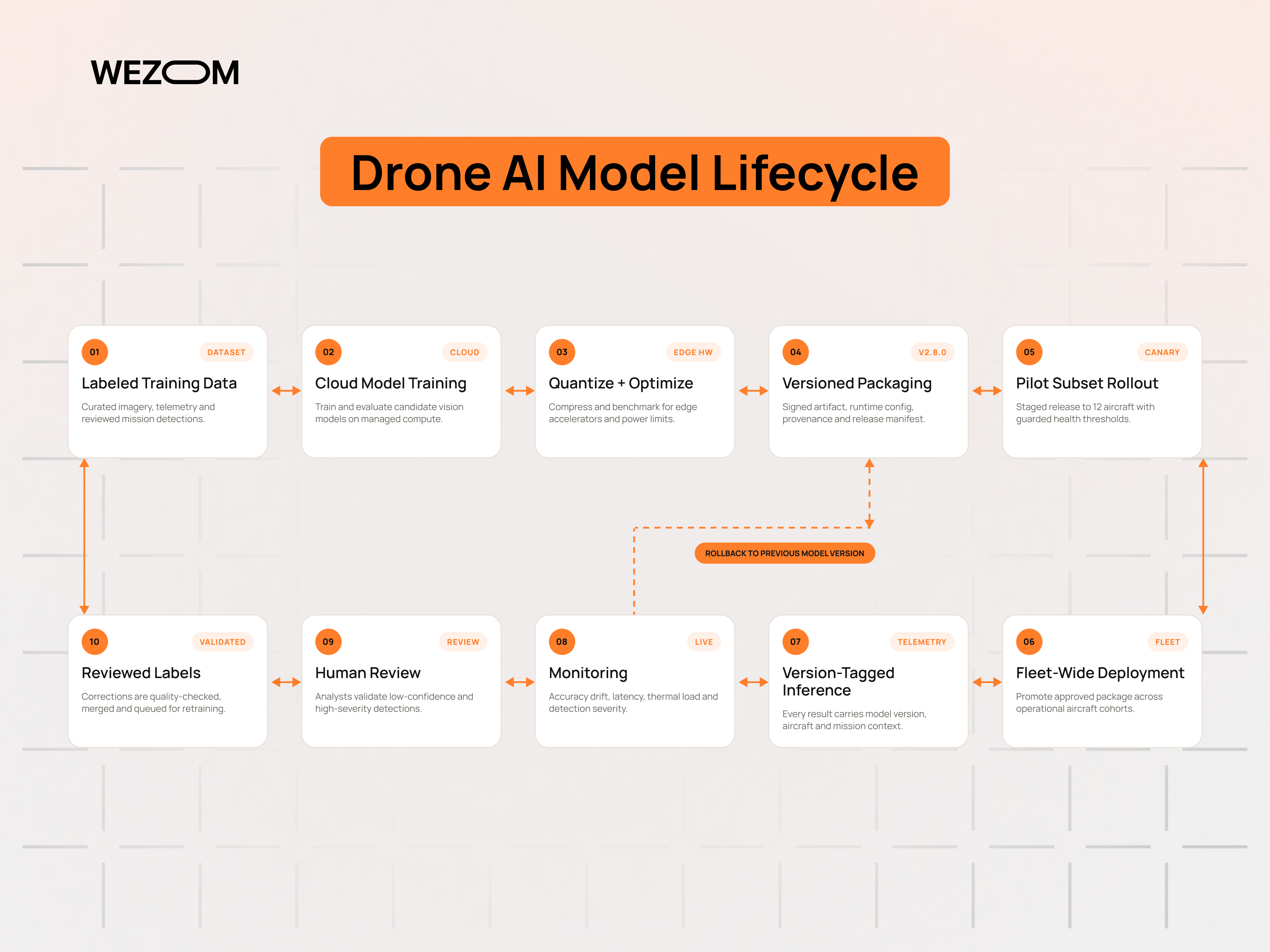
Deploying and updating AI models across drone fleets
Model updates across a fleet need versioning, staged rollout, and the ability to roll back a device that begins producing degraded output. Every inference result should record the model version that produced it; otherwise, a change in detection rates cannot be attributed to the model rather than the asset.
Centralizing data from multiple UAVs and missions
A common data model across aircraft, sites, and missions is what makes fleet-level analysis possible. Mission identifiers, asset identifiers, and consistent coordinate handling belong at ingestion rather than reconstructed later. Programs that centralize late spend more effort reconciling historical records than early consolidation would have cost.
Turning analytics into repeatable operational workflows
Sustained value comes from repetition: fixed flight plans, consistent capture settings, defined severity rules, and automatic routing into the maintenance system. Once those are stable, adding aircraft or sites becomes an operational change rather than a new project, and the historical record stays comparable year to year.

FAQ
How quickly can drone data be processed after it is captured?
It depends on where processing runs. Onboard inference produces detections within roughly a second of capture, fast enough to redirect the aircraft mid-mission. Edge or ground-station processing typically returns results within minutes of a completed pass. Full photogrammetric reconstruction of a large survey remains a batch job measured in hours, driven by image count, overlap, and available GPU capacity rather than by the analytics platform.
Can drone analytics work without a continuous internet connection?
Yes, provided the architecture is designed for it. Inference on a companion computer or ground station needs no external connectivity, and results can be written to local storage and mapping software. The platform then queues detections, media, and logs and reconciles them when a link returns. What degrades offline is cross-site comparison, cloud reconstruction, and model retraining, not detection itself.
What hardware is required for onboard AI processing on a drone?
Typically an embedded GPU or NPU module, such as those in the NVIDIA Jetson or Qualcomm families, mounted as a companion computer with a direct camera interface and a link to the flight controller. Selection is constrained by payload mass, sustained power draw, and thermal dissipation in flight. Heavier compute reduces endurance, so the module is chosen against the specific models that must run, quantized, at the required frame rate.
How much data can a drone analytics platform process simultaneously?
There is no universal figure, because concurrency is an architectural property rather than a product specification. Cloud platforms scale ingestion and inference horizontally, so practical limits come from quotas, cost, and queue behavior under burst load. Edge deployments are bounded by the hardware present. Operators running several simultaneous missions should test with representative stream counts and payload sizes instead of relying on stated maximums.
Can historical drone data be combined with live flight data?
That combination is what makes change detection and condition monitoring possible. It requires consistent georeferencing, a stable asset identifier scheme, and comparable capture parameters between flights. Where older surveys were flown at different altitudes or with different sensors, they still provide context, but quantitative comparison needs normalization and corresponding caution.
How accurate are AI-generated insights from drone imagery?
Accuracy varies by defect class, ground sample distance, lighting, and how closely the training data resembles operating conditions. Large, high-contrast features are detected reliably; small or low-contrast defects at altitude are not. Any stated accuracy figure is meaningful only against a labeled validation set from the same environment, which is why programs measure precision and recall per class on their own data and route uncertain cases to review.
What affects the cost of developing a custom drone analytics solution?
The main drivers are the number and difficulty of the models to be trained, the volume and quality of labeled data available, the depth of integration with GIS, ERP, and maintenance systems, whether inference must run on constrained onboard hardware, and any security or data residency requirements. Ongoing costs come from retraining, infrastructure, and maintaining compatibility as fleets and payloads change, and over a multi-year horizon these often exceed the initial build.
